ENTS
The calendar may have set September 23 as the
first day of autumn in 2007, but the forests that line the eastern
shore of Lake Superior had already started to mark the turning of
the season. By September 23, when the Moderate Resolution Imaging
Spectroradiometer (MODIS)
on NASA's Terra satellite
captured this photo-like image, the forests of northern Michigan
and southern Ontario flamed orange as the first trees of the
season--maples--began to display their brilliant red and orange
fall colors. Veins of green run through the sea of orange where
the deciduous forest gives way to deep green pine trees.
The most vivid color is concentrated in Canada's Ontario
Province. Located farther south, Michigan's trees show only a hint
of color. The St. Mary's River seems to be the dividing line
between the brightest colors and the as-yet-unchanged forest. The
river is also the border between the United States and Canada, as
well as the only waterway linking Lake Superior to the rest of the
Great Lakes. Orange and green forest gives way to gray along the
banks of the river where the cities of Sault St. Marie, Ontario,
and Sault St. Marie, Michigan, are located. Separated into two
cities by the split between Canada and the United States after the
Revolutionary War, the city was the first permanent European
settlement in either Ontario or Michigan. A faint tan line
spanning the river is the bridge that links the two cities. The
pale green grid south of Sault St. Marie, Michigan, reveals
patterns of land use, either from agriculture or forestry.
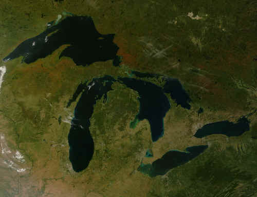
The large image provides an unusually cloud-free view of all of
the Great Lakes. Similar spots of color stretch across southern
Canada and parts of Michigan, Wisconsin, and Minnesota. The
northern plains of the United States have started to turn yellow
as grasses ripen, but the eastern forests in Pennsylvania and New
York remain deep green. Red squares scattered throughout the large
image mark the locations of fires. The large image is at MODIS'
maximum resolution of 250 meters per pixel. The image is available
in additional
resolutions from the MODIS Rapid Response System.
Fiery colors begin their yearly
conquest of the hills, propelled by the autumn winds. Fall
is the Artist...........Takayuki Ikkaku.
Ed:
Thanks for showing us this image. Fall colors were early this year
due to severe drought conditions, otherwise color would not show up
until October.
The small image shows the maple belt along Lake Superior, although
notice that right along the lake is a lot of green, because its too
cold during summer for maple near Lake Superior, and conifers mixed
with aspen and birch dominate there. Thirty or so miles inland, the
maple also makes a transition to boreal forest, because it is too
cold for maple during the winter. Arctic air blowing over the lake
is warmed considerably during the winter (when its -40 in MN its -20
in Upper MI and the Ontario shoreline on the east side of the lake).
By the time the air moves 30-40 miles inland, it regains is coldness
and maple cannot grow there. So, that leaves a zone where it is
neither too cold during summer nor winter where maple can grow,
which shows up in orange in the picture. The Peninsula at the
northern edge of the small image is Lake Superior Provincial Park,
which has about 70 miles or so of shoreline.
The larger image shows the early fall color under severe drought
conditions in the Porcupine Mountains and Sylvania Wilderness areas
and at the tip of the Keweenaw Peninsula. No doubt in a better year
there would be more red than orange. The little spots of orange
color along the Minnesota North Shore of Lake Superior are isolated
maple forests at relatively high elevation surrounded by lowland
boreal forest. There is also a lot of dead forest on the Minnesota
North Shore from this year's drought--I think that just shows up as
light green because the shrub layer is showing through the canopy of
dead trees.
Lee
Lee,
Very interesting commentary about the
image. I subscribe to Nasa's Earth Observatory mailing:
http://earthobservatory.nasa.gov/
which sends me once a week some links and posts six or seven earth
satellite photos. Sometimes they are tree related and I
forward the address for the ones I think in which the group might
be interested.
Ed Frank - October 04, 2007
|