|
ENTS,
Yesterday morning, Monica and arose early, packed our gear, and
drove the enjoyable 34 miles to Charlemont, MA. We had a date for
breakfast at the historic Charlemont Inn. While there, we always
chat with the Inn's owner and our dear friend Charlotte Dewey.
Breakfast at an Inn that has entertained historic personages to
include Ethan Allen, Benedict Arnold, gentleman general John
Burgoyne, Henry David Thoreau, and even the inimitable Mark Twain,
should give one pause to reflect about the amount of history that
the Inn has seen. The Inn is the traditional site of our October
ENTS rendezvous after a mid-day climb of a Mohawk tall tree by our
esteemed president Will Blozan.
After leaving the comfort and hospitality of the Inn, we headed
for our forest Mecca. Our goal was to climb up onto the original
Mohawk Indian Trail. There are two historic Indian pathways across
Hoosac Mountain that imparted the collective name the Mohawk Trail,
which has become known as State Route 2 in western Mass. The trail
(or trail network) joined the waters of the Connecticut River in
Massachusetts with those of the Hudson in New York via the
Deerfield, Cold, and Hoosic Rivers. Within the area now designated
as Mohawk Trail and Savoy Mountain State Forests, the lower
elevation path along the Cold River has fallen into obscurity. In
reality, it no longer exists. However, a part of the upland, or the
mountain path, our destination, remains to this day. It follows the
crest of the Todd-Clark Ridge in Mohawk Trail State Forest. I have
taken it many times and I will take it many more.
I never tire of that little meandering mountain path, the path
once taken by King Philip of the Wampanoags in his abortive attempt
to solicit help from the Mohawks of New York to drive out the
colonists in New England once and for all. King Philip failed in his
attempt, but his journey across the trail, along with Mohawk forays,
and later the British and Colonists affords us a walk back through
time.
The mountain branch of the Mohawk Trail has always existed as a
trail. The pathway was never lost. Especially in the fall, when I am
alone on the trail, I can almost hear the footsteps of Indians,
Colonials, and British Soldiers locked in a war that first pitted
indigenous peoples against one another, then against the brash
European interlopers with an unquenchable thirst for land and
absolutely convinced of a manifest destiny that they would enforce
through superior numbers and weapons technology. That was the French
and Indian War period. Later the trail was used during the
Revolutionary War. After that it fell into disuse. It was always a
challenge to travel for soldiers and colonists with ox drawn carts.
Ox rock was once the site of a dreadful accident.
Along the secluded 1.2-mile stretch of the original mountain
branch of the Mohawk Indian Trail that remains today, the veil that
separates the present from a violent past is thinner. One senses, if
dimly, the outline of the struggle for dominance. On windy
days, carried on the breezes, messages are whispered into the ear.
Specters of Mohawk, Mahican, and Pocumtuck warriors return to
re-experience violent ends along the trail, or perhaps just to
linger in a land that was once theirs.
The old Mohawk Indian Trail is multi-dimensional, both a metaphor
and a reality. A walk along the trail can be experienced on many
levels. When hiking the trail, I often stop to contemplate the
beauty of my physical surroundings, only to drift into reverie. What
happened at the spot on which I stand, I ask myself? Whatever the
distant events, I imagine they were somehow recorded as they
happened and embedded in the trunks and limbs of the nearby twisted
oaks and hemlocks. A few of those trees still stand today. I
experience a shiver. Can the old trees really hold such memories? Do
arboreal sentinels along the old Indian trail continue to bear
silent witness to the passing of an indigenous culture that held
dominion in the wild forest? For centuries that forest nourished the
land, cloaking and protecting it. Then a new breed with light skin
unceremoniously thrust itself into the green. Bold, greedy, and
ignorant of the ways of the new land, they sought to impose their
will. They ushered in an era of rapid change, change not to the
liking of the ancient rocks of the mountain or its covering of
virgin forest, or its animal denizens. I think about these things
when I walk the trail.
For thousands of visitors, the Mohawk Trail is a paved road that
offers scenic views from the French King Bridge, through the Cold
River Gorge, and across the Hoosac Summit. The road, built in the
early 1900s, passes through the historic mill town of North Adams
and then through classy, collegiate Williamstown before it mounts
the Taconics at Petersburg Pass. In the bustling places, memories
and traces of the trail have long vanished. But up on Hoosac
Mountain, the atmosphere is different. Nature maintains a precarious
hold. Motorists stop at the eastern and western overlooks along
Route 2, visit gift shops, snap pictures, and move on. They get
their fill quickly - a sign of the times. But near the eastern gate,
not far from the thin corridor of intrusive Route 2 pavement runs
another trail, an older one, the real one, the one we sought, and
the one we want to share with you in the coming months.
We hope the attached images will give you, our readers, at least
a little of the flavor of the old Mohawk Indian Trail. Photographing
this historic pathway and describing it in prose is now a high
priority mission of mine, if not an obsession. I feel compelled to
capture as much of the lingering essence of the trail and its hidden
treasures as my talents will allow. Over the coming months, I plan
to present a series of "Internet walks" along the old Indian trail
with photos, descriptions, and naturally, tree measurements in
abundance.
On a very fundamental level, the current Mohawk Trail is a tale
of trees, young and old, short and tall, of 30-odd species. As I
have reported in the past, Mohawk Trail State Forest's Rucker Index
is 136, third highest that we know of in the Northeast and many of
the champions are close to the trail. But beyond the stately class
of tall trees of over 20 species, are the hulking forms of truly
great trees - the white pines that fired the imagination of
colonists, the British Navy, and sages like Thoreau. So, there is
much to share and without further commentary, I'll get to the
images.
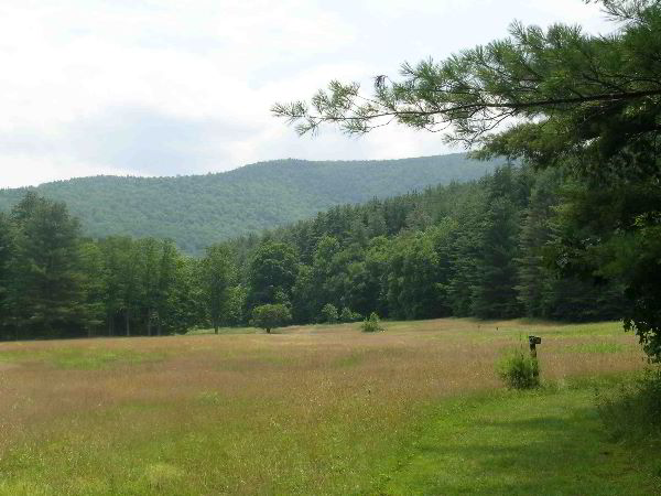
The first image "LowerMeadow" shows one of two enchanting meadows
in Mohawk Trail State Forest. The original trail just skirts the
lower meadow - a fitting place to start our journey. The lower
meadow is where Mohawk Chief Jake Swamp planted a white pine in a
ceremony he held in May of 1994, honoring travelers of the original
Mohawk Trail. Alas, the pine has since died, the victim of having
been run over by a mower; nothing intentional.
The middle of the lower meadow has its own unique history. It is
the route of the historic shunpike of the 1760s. The route was
devised to allow travelers to avoid tolls on the nearby toll road
that ran along the Deerfield River and across Whitcomb Summit. The
Shunpike still exists on the slopes of Clark Ridge, one of the day's
destinations.
It should never be forgotten that surrounding the historic Indian
path is a venerable forest, an old growth forest of trees, many
which have seen 300 and more winters. In my mind, these splendid old
trees are the deep Earth anchors that keep Mohawk whole, functioning
as an intact ecosystem. So, it is appropriate that we continue our
photo journey with a view of some of the most honorable Mohawk
residents. By the way, please remember that these photos can be
expanded to see greater detail. Let the journey continue.
For me, the trek up the Todd-Clark ridge on the Mahican-Mohawk
Recreational Trail starts in tranquil Stafford Upper Meadow, where I
linger gazing at the face of Todd Mountain and an ancient forest
that I helped to document. One passes through the meadow and enters
the majestic Algonquin Pine Grove with its towering trees that brush
the sky. The Algonquin grove has two of our 160-footers and will
probably add 2 or 3 more in the next 5 years.
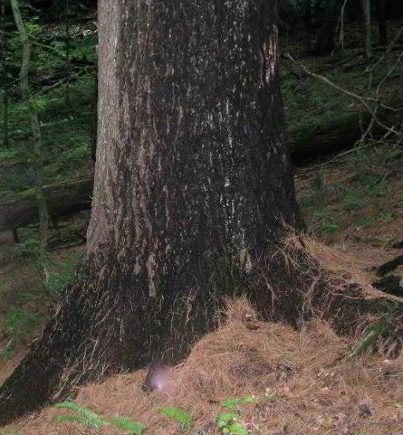
Beyond the pines, one passes through a gateway of large, opposing
rocks. Then, one notices two large, white pines on the uphill side
of the Mahican-Mohawk Recreational Trail. The trees are
exceptionally handsome. Long ago, I named them the Northern
Sentinels. They stand as guardians over the trail. The image
entitled "OnMMRTNorthernSentinelUpper" shows the uphill sentinel. It
is not a small tree. Of course, as Monica and I reached the
sentinels, I had to stop and remeasure them both. It is a ritual
that I follow- a way of honoring those gallant forest beings. I
communicate with them through numbers. Measuring them is my way of
shaking hands with them.
The upper sentinel is a substantial 10.4 feet in girth and just
makes 138.0 feet in height. I remember when it was 132. The lower
sentinel is a comparable 10.1 feet around and 137.5 feet tall. These
twin pines occupy a dry spot on the side of the ridge. They will
eventually surpass 140 feet in height and perhaps reach 145 feet.
Each may reach 11 feet in girth. But, if achieved, those dimensions
will be strictly by the will of the local forest spirits. I believe
that the pines are closing in on the maximum sizes that can be
achieve for the growing conditions that they've inherited.
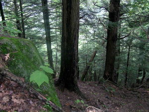
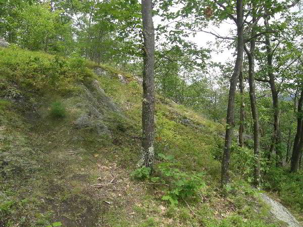
The second image "OffOrigMTTToddRidge" provides a glimpse
into the forest as it appears off trail on the steep side of Todd
Mountain - the path of our return. On the upper slopes of Todd and
Clark, eastern hemlocks reach ages of 200 to 350 years with a few
exceeding 400. Elsewhere in Mohawk trail State Forest, there are
even older hemlocks. One hemlock on the south side of Route 2, high
on the ridge, is now not less than 500 years old.
Parts of Todd Mountain are very steep with large, jumbled
boulders and precipitous ledges that served to protect forest
remnants from the axes and saws of earlier generations and the
Brontosaurus-sized timber extractors of today. In those days, it
took imaginative souls like Henry David Thoreau to warn of the loss
of our precious natural heritage that had shaped the land for
thousands of years. However, few were listening then. More are
today, but new threats to our forests have emerged. It took
unaccessible terrain to save those morsels. It will take an
unrelenting battle to fight off today's forces of destruction.
In the steep slope image, leaves of northern red oaks and a
bright green leaf of a striped maple hint at a broader forest
diversity than that which commonly exists beneath the old hemlocks.
That diversity will be revealed in the next image. Least the
carpet of needles under hemlocks and pines lead the reader to
believe that undergrowth is sparse in along the trail, consider what
happens on the boulder fields. The image entitled "OnMMRTIntoThe
Green" was taken a hop, skip, and jump from the trail. It shows
luxuriant undergrowth. Minerals released from the schist as it
slowly decomposes from action by the lichens, combined with abundant
moisture, produces flourishes of plant growth. Yellow birch are
especially suited to grow among the crevices in the rocks.
As a side note, the slopes of Todd and Clark Mountains and in the
Trout Brook Cove, all in Mohawk Trail State Forest, receive between
50 and 55 inches of moisture per year. The environment is wet,
protected, and nourishing. The trees respond by reaching the
greatest heights in all New England. Our perenniel champion, the
Jake Swamp Pine, grows on the toe slopes of Todd Mountain a stones
throw from the colonial Mohawk Trail. Jake now stands a noble 169.3
feet above its base. You cannot find a taller tree in all New
England. The Jake Swamp Tree is a state treasure.
Once the 1,000-plus-foot climb up Todd Mountain has been
completed and one's feet are securely on the old ridge- line Indian
Trail, one can more leisurely embrace the cultural mysteries of the
trail - or drift off into a reverie, a mood of deep appreciation. It
is in these moods that real connections are made to the trail.
To first time visitors, it can seem almost inconceivable that
this is Massachusetts, far removed from the hustle and bustle of the
urban centers and all the artificial priorities that we humans are
inclined to generate. That we have such a compelling landscape left
in populous Massachusetts falls within the realm of minor miracles.
The scene from near Indian Lookout on Todd once prompted my friend
Bill McKibben to state in his walk with me that the view from
Todd-Clark is one of the most understated in all New England. Bill
had tuned into to the spirit of Mohawk.
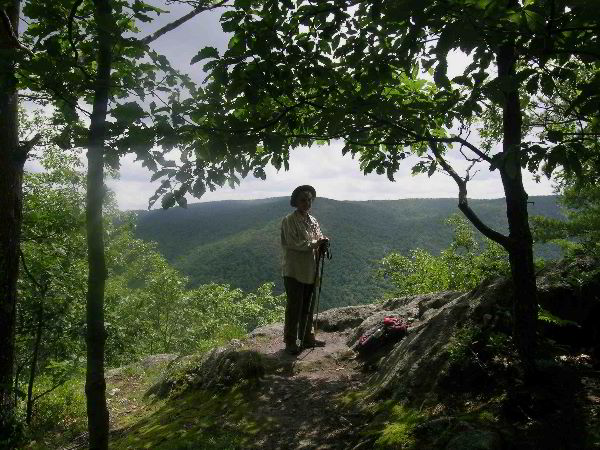
The image entitled "OnOrigMTMonica" casts Monica in the shadows
surrounded by a cloak of chestnut oak leaves. The area near the
ridge crest is no stranger to past fires that raced up the slopes
and destroyed the thick humus layer that had protected the summit of
Todd before the appearance of Europeans intent on creating sheep
pasture on the lower slopes. The loss of soil from the fires allowed
the chestnut oak to gain a slight advantage over the predominant
northern reds.
The view through the oaks looks toward the highest elevations of
Mohawk Trail State Forest. One unnamed point achieves an altitude of
2080 feet , giving nearly 1,500 feet of vertical relief to Mohawk's
ridges. The high point is back of Monica's hat and slightly to the
left - the more distant point.
The scars of old fires that burned up the south-facing slopes of
Todd are the subject of "OnOrigMTOldBurns". I believe that these
fires occurred primarily from a couple of post-colonial settlements
at the base of Todd. I have visited the old foundations on numerous
occasions. Interesting plants have colonized the areas of old burn,
including several rare ones. Despite the soil destruction, the
meadow-like openings are not without their charms. Distant vistas,
soaring turkey vultures and hawks, gnarled trees, and artistically
sculpted rock formations have the power to transform, to bring one
into harmony with one's surroundings.
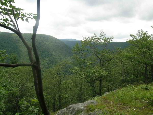
The final image "OnOrigMFColdRiverGorge" looks up the Cold
River Gorge through the western part of Mohawk Trail State Forest
and into adjoining Savoy Mountain State Forest, site of some dubious
forestry practices promulgated on misguided ideas about what
constitutes health in a forest. Dare I mention that there is a
struggle taking shape that will pit the forces of forest
exploitation, falsely presented to the public as forces of
enlightened management, against the forces seeking to preserve the
best of what we have left. But even the distant insults to Savoy's
forests do not diminish this gorgeous view of the Cold River
country. Here Massachusetts is seen at its scenic best.
Bob
Continued
at:
http://groups.google.com/group/entstrees/msg/843515fd9146682a?hl=en&
|