Return to Mount Logan
June 04, 2009. I
revisited Mt. Logan natural Area accompanied by Lin Greenaway.
Lin is an ENTS member and a forester with the Pa. Bureau
of Forestry. I
first visited Mt. Logan in October 2007.
http://www.nativetreesociety.org/fieldtrips/penna/mount_logan_07a.htm
Mount Logan is a state forest Natural Area located in
central Pennsylvania just south of the town of Lock Haven.
The location is described on the PADCNR website as:
"A 512-acre tract features an old growth eastern hemlock
stand and an outcrop of Tuscarora sandstone, both near the
summit." This
is almost correct.
The rock outcropping at the hilltop is the Tuscarora Quartzite,
a metamorphic rock, not sandstone.
Geologically the ridge containing Mt. Logan is at the
westernmost edge of a large anticline/syncline series know as
the Ridge and Valley Province where it adjoins the Allegheny
Plateau.
These massive folds formed in the Carboniferous Era, 300-350
million years ago, during the Allegheny Orogeny when Gondwana
(specifically what became Africa) and what became North America
collided, forming Pangaea.
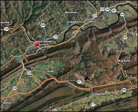
Annotated air photo of the area showing the geologic
structure. Mount Logan is in the center of the image
immediately below Route 220.
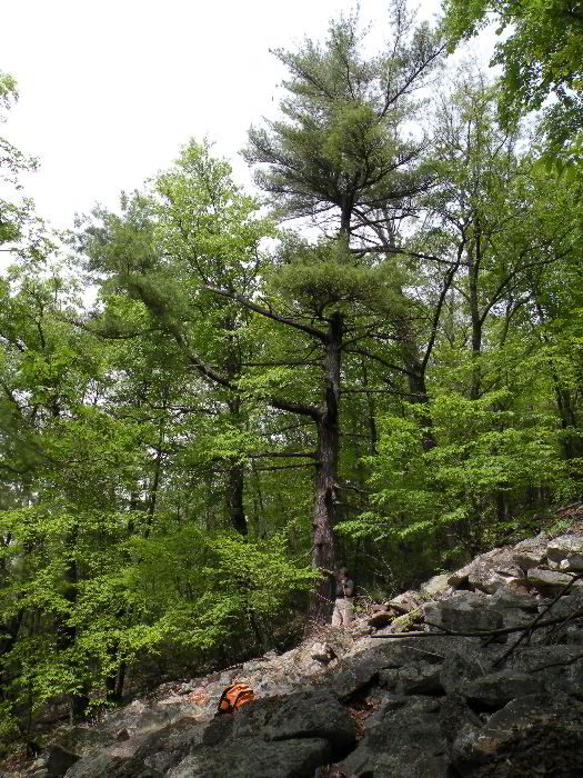
What most impressed me the first trip was not the somewhat
stunted white pine and hemlocks atop the mountain, but were the
bent old trees growing on the massive talus slope on the south
side of this east-west oriented ridge.
Some of the trees on the summit were reportedly cored to
ages over 200 years. Many of the trees growing in the talus
slope are in my opinion every bit as old as those at the top, if
not older.. On the
first trip I collected some height measurements, but lost my
camera. In the case
of these types of trees it is not so much the height and girth
of the trees that are impressive, both are relatively small, but
it is their form that is of interest.
The goal today was to explore more of the site and to
retake photos of the site missing from the first trip.
http://www.dcnr.state.pa.us/forestry/stateforests/maps/fd07_map.pdf
I met Lin just south of the site.
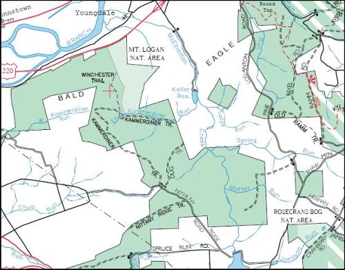
We carpooled taking her state vehicle up the rough and
rocky Kammerdiner Trail.
There is a nice parking spot just before the trail jogs
abruptly to the east. The
day was beautiful. It was sunny but still cool after
several days of cold drizzle. We parked and walked from
the parking area down the trail/road to the start of the rocky
footpath that is the Winchester Trail.
This section of the road crosses a topographic saddle
between ridges to the north and south, and valleys to the east
and west. What is
significant about this saddle is a series of large vernal pools
along the south side of the road.
I am sure I noticed them the previous trip, but they did
not make it into my consciousness.
Vernal pools are defined by the PA Game Commission as:
“Seasonal pool wetland ecosystems, known commonly as "vernal
ponds," are isolated from streams, rivers, and other bodies of
water and characterized by a seasonally fluctuating water level,
often drying out completely for some part of the year. Vernal
ponds are often small, seemingly "minor" waterbodies that are
particularly important to amphibian populations.”
http://www.pgc.state.pa.us/pgc/cwp/view.asp?a=496&q=165000
Unfortunately we did not have time to examine the vernal pools
in detail, but I grabbed some photographs. Lin found a
salamander near a puddle in the road as we walked along this
stretch.
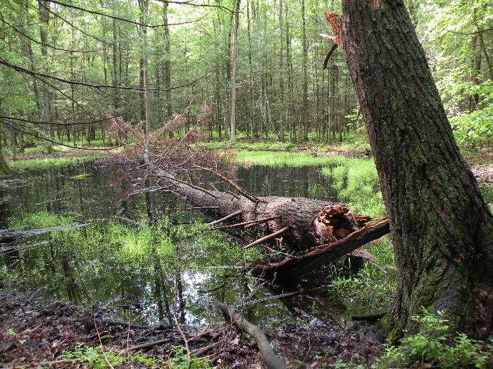
Vernal Pool with a newly
fallen pine log.
The Winchester Trail is a blue blazed leads straight up the
mountainside gaining 500 feet in a short distance to the
mountain top along the western edge of the natural area. The
first section of the trail rises gently through a younger second
growth forest. This
area had been cut in the early 1900’s, but had not been reworked
since.
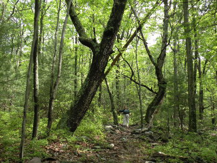
A pair of red oaks on either
side of the Winchester Trail.
Soon the toe of the talus slope proper is reached.
The talus consists of quartzite rocks from cobble to
boulder sized, generally ranging from 2 to 6 across and
flattened. These
talus slopes are a periglacial feature dating from the last ice
age. General
mass-wasting processes, and freeze/thaw cycles would separate
the rock along cleavage planes formed during metamorphosis and
deformation of the Tuscarora Quartzite. These freed rock
fragments then fell, rolled, slid and creeped down the grade to
form a large talus slope. Similar talus slopes are also present
along the north side of the ridge in some areas.
The talus piles are at approximately the natural angle of
repose for material at 42.4% (23 degrees).
This means that the pile is for the most part stable,
with only a slow amount of creep occurring over time.
There is limited vegetative cover on much of the talus
slope on the southern side of the ridge and scattered open
barren areas.
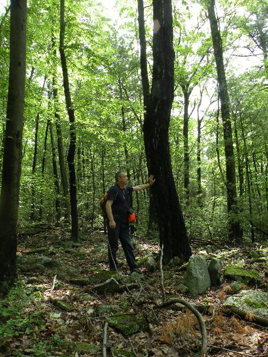
White Pine tree growing on
the talus slope. In my estimate and Lin concurred, this
tree is easily 200 years old. Height 65.3 feet, girth 6'
1"
On this talus are the dominant tree species in the short canopy
were yellow birch (Betula alleghaniensis), red oak (Quercus
rubra), red maple (Acer rubrum), chestnut oak (Quercus Montana),
and white pine (Pinus strobus).
In the understory striped maple (Acer pennsylvanicum) and
mountain laurel (Kalmia latifolia) were prominent.
It was surprising that red oak was more common in the
talus slope than chestnut oak.
American chestnut (Castenea dentate) was also fairly
common in the understory. Many other species including cherry,
common serviceberry or juneberry (Amelancher arborea), black gum
(Nyssa sylvatica), and butternut (Juglans
cinerea) were present in lesser numbers or occasionally
on the talus slope.
Near the top on the south side were a scattered handful of
eastern hemlock and even sassafras.
Ground cover in the talus field was sparse.
There were various lichens growing on the rocks
themselves – rock tripe, reindeer moss – and various other
unidentified crustose, squamulos, fruticose, and foliose
lichens. Some
species can only be identified through chemical analysis.
Various mosses, patches of huckleberry, hay scented fern,
currants, and Virginia creeper were also present on tiny pockets
of soil.
On the original trip I only measured a few individual trees.
|
Species
|
height
|
girth
|
longitude
|
latitude
|
|
White pine
|
65.3 ft
|
6' 1"
|
77' 22.118
|
41' 07.512
|
|
Yellow birch
|
51 ft.
|
4' 6"
|
77' 22.116
|
41' 07.544
|
|
Red oak
|
57.5 ft.
|
7' 9"
|
77' 22.122
|
41' 07.548
|
|
Chestnut oak
|
45 ft.
|
4' 7"
|
77' 22.103
|
41' 07.576
|
On this one I just measured a butternut.
It was located along side of the trail in the talus
slope. The tree
appeared to be healthy and we could not see any signs of canker.
The Butternut canker disease,is caused by the introduced
fungus Sirococcus
clavigignenti-juglandacearum. In some areas, 90% of the
Butternut trees have been killed.
Butternut tree. Height 74 feet(looking up), Girth 4' 11"
|
Species
|
height
|
girth
|
longitude
|
latitude
|
|
Butternut
|
74 ft
|
4' 11"
|
77' 22.136
|
41' 07.384
|
I am not sure how to deal with this situation.
The trees are stunted, some more than others.
Some of the trees that have the most character, the ones
that appear to be among the oldest, are neither the largest nor
the smallest of the trees present.
I could go back again when I have more time and try to
develop a Rucker Index for just the talus slope area, but with
the irregular heights I am not sure what is gained by a Rucker
Height Index. The
focus on height for sites like these does not seem to be
meaningful. Perhaps
a Rucker Girth Index would better represent the features I am
seeing. There
really needs to be some better way the evaluate sites with old
but stunted forests than we have in our repertoire presently.
Birch. The tree is slanted because of movement of the
rock substrate during the life of the tree. The branches
are again curving upward after the tree tilted.
Once we reached the toe of the talus slope we spent more time
looking at the trees present.
The red oaks and chestnut oaks were being heavily hit by
gypsy moths. The
moth caterpillars were present everywhere.
In many of these oaks as much as 90% of the canopy had
been eaten. Small
fragments of leaves covered the floor under the oak trees.
While walking along it sounded almost like a light rain
as the debris and droppings from the caterpillars fell from
above. The gypsy moth had not been present on my previous trip
in fall 2007, or at least it was not present in numbers to be
noticeable. The
effect on this particular forest could be drastic.
These trees are small and stunted because they are
already growing in less than optima conditions.
The additional impact of the gypsy moth will add
additional stress to their existence and may cause a high
mortality rate among these old trees.
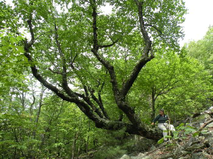
When you look at the thick bark, heavy branches, and
often bent form of these trees and think of the length of time
they have managed to eek out an existence, it seems unfair that
their life could be ended by an invasive insect infestation.
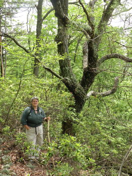
Chestnut Oak. Lin is
some distance in front of the oak and this distorts the size
relationship. The tree is 45 feet tall and 4' 7" in girth.
The branch pattern is that of a open grown tree because the rock
slope is a generally open patchy setting.
While in the talus slope area I took a number of pictures of
trees that are representative of those living there.
Given time I could find hundreds of trees much like the
ones photographed growing in the talus.
At the moment this is the best way I can figure out to
document what is
present on the site.
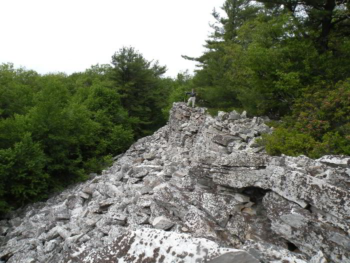
View of the Tuscarora Quartzite outcrop. Lin is for
scale.
At the top of the slope the hill flattens out for a short
distance. At the
crest of the mountain is a
ridge 20 to 25 feet high of Tuscarora quartzite forming
a spine running
east-west down the length of the mountain.
It is beige to bright white in color.
This is the same unit that outcrops to form Seneca Rocks
in West Virginia.
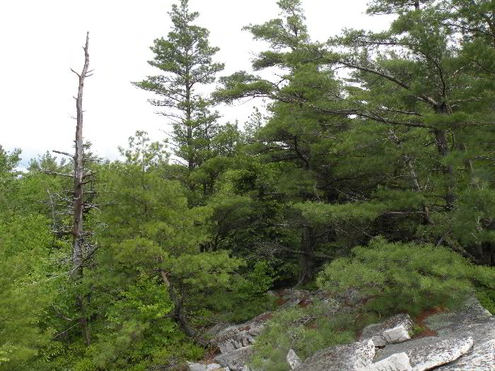
Small white pines, hemlock, oaks, mountain laurel, and birches
grow atop the rock. There were scattered examples of other
species including among others cherry (sp.), American chestnut,
red maple, and pitch pine .
It is on the north side of this ridge outcrop that the
old growth conifers had been described in previous published
reports. One source was by Charles Fergus in "Natural
Pennsylvania - Exploring the State Forest Natural Areas."
Chuck Fergus is a well know Pennsylvania outdoor writer
who has authored many field guides for the state and had a long
time column in the Pennsylvania Game News.
According to his report there was a patch of about fifty
acres of old growth surrounded by younger second growth trees.
Mr. Fergus had reported in his article that a former
forester had told him that hemlocks in this area had been cored
to over 200 years.
I also had read an account of the area by Marcia Bonta -
also a PA outdoor write with a current column in the PA Game
News.
http://marciabonta.wordpress.com/category/old-growth-forests/
One my first trip I pushed into the thicket at the edge
of the quartzite outcrop and found the edge of this old-growth
patch. Ernie Ostuno had visited the site in July 2004.
He reported, “The old growth is only about two or three
acres in extent and consists of about 15 hemlocks and a few
maple and yellow birch. The old growth is located near the top
of the western slope of the headwaters of a stream valley, and
less than 100 yards northeast of the ridge where an outcrop of "tuscarora
sandstone" occurs.
I would disagree with Ernie Ostuno’s assessment and would expand
the old growth forest area to include much of the forest on the
talus sloe itself, and portions of the hemlock/pine forest on
the northern side of the ridge.
It is possible that this area was bypassed on his trip
and that the area he described is another location on the ridge.
On neither trip have I had the time to explore the
boundaries of the old growth forest patch.
Certainly there are stunted younger trees atop the ridge
and these may be difficult to distinguish from actual old growth
trees. I would like
to see the area more fully explored with a modicum of tree
coring done to better establish an age structure for the site.
There is no evidence I could see that the trees on the
top of the ridge and on the talus slope itself have ever been
harvested. The
younger age of the trees in some of these areas may be because
of forest fires or other natural disturbances rather than human
activity. This area
could very well be a primary forest system dating back to when
the area was first forested thousands of years ago, even if some
of the trees themselves are not that old.
Perhaps with tree ring analysis a fire history could be
developed for the site and help answer some of the questions
Small white pine tree and low hemlock atop the ridge.
There were indications of porcupine activity on several of these
trees. White-tail deer droppings were found on the talus
slope. Timber Rattlesnakes are known to be present in this
area but none were encountered on this trip.
Lin and I explored the top of the ridge briefly but did not have
the time to explore beyond the edges of the outcrop before we
had to leave. The
trip down the mountain and back to the vehicle were uneventful.
Edward Frank