June 09, 2009. Carl
Harting and I (Ed Frank) visited three sites in western
Pennsylvania on Tuesday.
These were Wolf Creek Narrows Natural Area, Hogg Woods,
and Plain Grove Fen.
I will post each portion of the trip separately
to better organize the information.
Wolf Creek Narrows Natural Area is located in Butler County in
western Pennsylvania a couple miles from the town of Slippery
Rock. This 100 acre
site was purchased by the Western Pennsylvania Conservancy in
1979.
http://www.paconserve.org/75th/wolf.htm
Wolf Creek is a modest
sized stream that flows through a narrow valley.
In portions of the site are located steep slopes to
cliffs as high as fifty feet overlooking the stream.
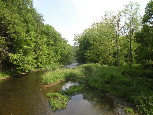
Wolf Creek from bridge -
photo by Edward Frank
Portions of the site along the floodplain, hilltop, and
shallower slopes were logged 80 to 100 years ago and have since
regrown into a secondary forest of yellow birch, hemlock, beech,
tuliptree, sugar maple, and red oak.
The forest on the steep slopes of the main valley and
tributary stream are reported to
be a remnant of virgin forest that has never been logged.
http://www.naturalheritage.state.pa.us/CNAI_PDFs/Butler%20County%20NHI%201991%20WEB.pdf
This forest is
classified as a northern hardwood forest, with most of the
species listed above and dominated by eastern hemlock
(Tsuga canadensis).
In addition to this remnant virgin forest patch the site is
known for its spectacular spring wildflower displays.
http://www.pittsburghlive.com/x/pittsburghtrib/s_187294.html This
article by Paul Wegman gives an excellent overview of the site,
although the suggested reason of why there is an abrupt change
in the stream valley orientation seems questionable to me.
The first posting about this site was by Carl Harting in August
2004 of a trip taken the previous winter.
http://www.nativetreesociety.org/fieldtrips/penna/wolf_creek_narrows.htm
He reported measurements
of several species:
|
Species
|
CBH
|
Height
|
|
Tuliptree
|
n/a
|
124
|
|
Tuliptree
|
4.2
|
103.5
|
|
Tuliptree
|
6.8
|
109.4
|
|
Red Maple
|
8.4
|
105.7
|
|
Sycamore
|
8.9
|
118.3
|
|
Sycamore
|
7.4
|
117.3
|
|
N Red Oak
|
7.4
|
108
|
|
Beech
|
7
|
109.3
|
Carl and I met at the parking area just across the bridge from
the trailhead. At
the trailhead is a kiosk that has a map of the site and some
information about the flowers found on the site.
The mile long trail is essentially balloon shaped.
The trail runs across the floodplain along Wolf Creek to
just past the point of the large bend in the creek.
From here it climbs up the valley wall and runs along the
top of the valley rim until it cuts back across the hilltop,
just north of the open square on the air photo, to rejoin the
original trail section a few hundred yards from the starting
kiosk. The Western
Pennsylvania Conservancy property also includes areas on the
other side of the creek that can be reached when the water is
low enough for wading.
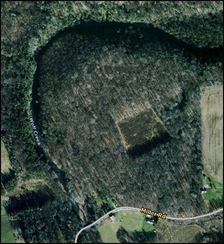
Air photo including Wolf Creek Narrows Natural Area
It was a warm humid morning and the mosquitoes were quite thick.
The trail was well marked with blue blazes and easy to
follow. Walking
along the floodplain we came across some relatively large
sycamores. Some of
these were the ones measured by Carl on his first trip.
It is a beautiful little stream.
We did not encounter many flowers as it was past peak
bloom season. Carl
said that in the spring the ground was covered by trilliums.
The canopy was very thick and it would have been next to
I possible to get good height readings of the trees through the
tiny openings available to us.
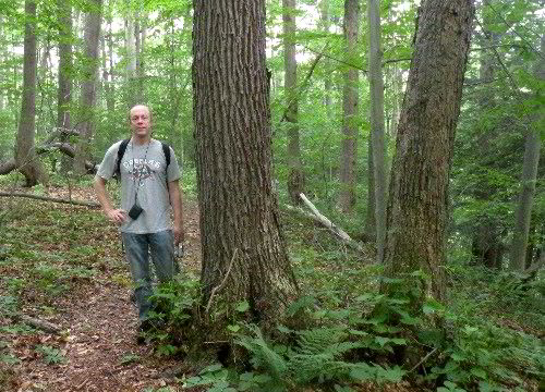
Carl Harting at Wolf Creek
Narrows Natural Area - photo by Edward Frank
So rather than measure today, we explored a bit and determined
to return after leaf fall this autumn.
Some of the trees we passed on the slope did appear to
have some age to them, but none were of any great size.
Scattered shots showed heights for most trees being 100
feet or less. I
think it is certainly worth revisiting and getting more
measurements, but again I have some concerns about how the site
will be represented by a Rucker Height Index.
Many of the trees appear to be old, but they are not of
great size. Using
just simple size parameters for these types of forests make them
indistinguishable from a common secondary growth forest.
I guess that is what descriptions and photographs are
for, but I wish there was some better way to quantify the values
of these forest in a way that would distinguish them from
younger, post-logging, secondary stands.
Aside from massive amounts of tree coring, I don’t know
what else to do.
There were some vernal pools near where the loop connected back
into itself that are of importance to amphibian populations.
Edward Frank