|
==============================================================================
TOPIC: Ft. Machault & Hoge Island-Allegheny River
http://groups.google.com/group/entstrees/browse_thread/thread/e466e7c5eef3f5c2?hl=en
==============================================================================
== 1 of 1 ==
Date: Fri, Oct 24 2008 8:04 pm
From: "Dale Luthringer"
ENTS,
On 9/5/08 I had a trip to Franklin, PA to research a canoe purchase
for
the park. After I was finished, I took some time to scout the old
Ft.Machault site and Hoge Island. Ft. Machault was one of the
original
French forts built on the Allegheny River drainage during the French
&
Indian War:
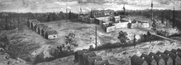
An artist's rendition of the French Fort Machault and the barracks
erected nearby.
http://www.explorepahistory.com/displayimage.php?imgId=1664
http://www.brigniagara.org/Warforempire.htm
"In the spring of 1753, French forces departed Montreal to
establish a
chain of forts in the Ohio country. Originally ordered to go to the
Chautauqua area, they received new orders changing their destination
to
Presqu'ile (modern day Erie, PA). The French force arrived at
Presqu'ile
on May 3, 1753. They began work preparing the site for the fort on a
bluff overlooking the peninsula and Lake Erie, near Mill Creek. The
French proceeded to build another fort at la riviere au le Boeufs
(present day Waterford, PA). From this spot the French could
transport
their supplies by la riviere au Boeufs (also known as French Creek)
to
Fort Machault (Venango) and the Ohio River where they would build
Fort
Duquesne (present day Pittsburgh)."
"1754
-The French reinforce their forces in the Ohio via lakes Ontario and
Erie and build Fort Machault (present day Franklin, PA) and Fort
Duquesne (Pittsburgh).
-Washington Surrenders Fort Necessity."
There is no visible structure of Ft. Machault today. If one can read
the lay of the land, and has some knowledge on how these forts were
set
up, one kind find the site with its associated terrain. I believe it
was located on French Creek, just upstream from the confluence of
the
Allegheny River. The entire site is now a "community
park".
Just up-river from the confluence of French Creek and the Allegheny
River is Hoge Island. I wasn't able to get on the island, but was
able
to observe some of its tree species. mainly silver maple. Small
stature
silver maple was located on the lower terrace, with larger silver
maple
dominating the upper terrace. From a distance, it looked like the
silver maple on the upper terrace would not have significant
heights.
Other species visible on the island include sycamore and black
willow
with Japanese knotweed on the river edge.
The old Ft. Machault site was a nice walk, but invasive species were
evident: Japanese knotweed, privet, tree of heaven. It was nice to
measure two new species for our Allegheny River drainage tally:
boxelder, fire cherry. Tree of heaven played games with me in terms
of
its ID. I never saw them this big before (medium tree sized). The
sumaras were quite distinctive. I wanted to call them black walnut
something fierce, but there were no nuts, and they certainly didn't
have
the bark:
http://www.cnr.vt.edu/dendro/dendrology/syllabus/factsheet.cfm?ID=7
Thankfully, I haven't seen these yet at Cook Forest. I didn't
measure
any, since they were heavily guarded by poison ivy on the ground and
crawling up their trunks, but they were decent in size, say
~14" DBH x
~60ft high. Next time I'm in the area I'll try to be a little more
persistent and see if I can get a decent height for one of these.
Also thought I'd add a fire cherry to our PA list at 0.9ft CBH x
24.3ft
high. Looks like a new state champ. first one on the list though.
Here's the day's tally:
Species CBH Height Comments
Boxelder
4.7
20.2
Butternut
8.8(3ft up) 72.1+
Fire cherry . 9
24.
3 41 23.391N x 79 49.249W
Honey locust
10
.4 73
Silver maple
N/A
87.1+
Silver maple
~20(2x)
91.1
Sycamore
N/A
90.9
Sycamore
N/A
98.8
Tree of heaven
~3.1
~60
Dale
==============================================================================
TOPIC: Ft. Machault & Hoge Island-Allegheny River
http://groups.google.com/group/entstrees/browse_thread/thread/e466e7c5eef3f5c2?hl=en
==============================================================================
== 1 of 5 ==
Date: Sat, Oct 25 2008 6:08 am
From: "Will Blozan"
Dale,
Cool stuff! I like the appearance of tree-of-heaven but not the
circumstances of their presence. Remember the fire cherries at
Tionesta we
saw with Jess? They were a good bit larger.
Will F. Blozan
President, Eastern Native Tree Society
President, Appalachian Arborists, Inc.
== 2 of 5 ==
Date: Sat, Oct 25 2008 7:06 am
From: djluthringer@pennswoods.net
Ahh,
Tionesta, I forgot about those. I can't see them in my head
though... can you
describe their rough location? Maybe that'll get the memory juices
flowing.
Dale
== 3 of 5 ==
Date: Sat, Oct 25 2008 7:20 am
From: "Will Blozan"
Dale,
They were on the edge of the tornado swath and along the roads. I
recall
some where we parked to go see measure the huge hemlock.
Will F. Blozan
President, Eastern Native Tree Society
President, Appalachian Arborists, Inc.
== 4 of 5 ==
Date: Sat, Oct 25 2008 11:55 am
From: djluthringer@pennswoods.net
Yep,
I got you. That's by the main parking loop. Next time I'm up there
I'll look
for them.
Dale
== 5 of 5 ==
Date: Sat, Oct 25 2008 8:03 pm
From: "Jess Riddle"
Dale,
For one of those Tionesta fire cherries I got 2'11" cbh by
51.4' tall.
Jess
TOPIC: Fw: [ENTS] Ft. Machault & Hoge Island-Allegheny River
http://groups.google.com/group/entstrees/browse_thread/thread/e1c7ebacb99eaa96?hl=en
==============================================================================
== 1 of 1 ==
Date: Sat, Oct 25 2008 8:34 am
From: "Edward Frank"
ENTS,
I have been looking on the internet regarding Ft. Machault. I sent
Dale an individual note saying that the location he described may
not have been the site of the fort. Dale replied: "According to
map, you're absolutely correct. I can't locate the source at the
moment, but one of the NW PA history books I read I believe said
that the original Ft. Machault was located just up French Creek, not
directly in view of the Allegheny River. It was soon abandoned and
another re-built in the more strategic location as noted in your
map. It was later burned by the French as they retreated up French
Creek towards Presque Isle after the fall of Ft. Duquesne. Also, the
site I explained might be better defined as where Ft. Venango was
located. Burnt by Indians during Pontiac's Rebellion.
http://en.wikipedia.org/wiki/Fort_Venango
In all, it's kind of confusing with three-four different forts built
in the same general area. Please post this and your pics/links to
the ENTS list. I've seen the historical marker to Ft. Machault. The
entire site has been entirely built over, be it roads or houses. The
canoe outfitter I was visiting has part of his business actually
located on this site. Please post this and your pics/links to the
ENTS list."
Wilkepedia - Map of Fort Machault
http://en.wikipedia.org/wiki/Fort_Machault
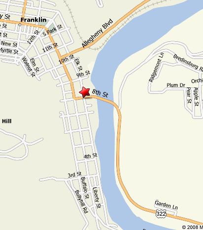
http://www.explorepahistory.com/hmarker.php?markerId=153
Credit: From A History of Venango County, 1879 Courtesy the
Pennsylvania Historical and Museum Commission (the marker says the
location is one block south of Elk and 8th (322).
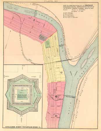
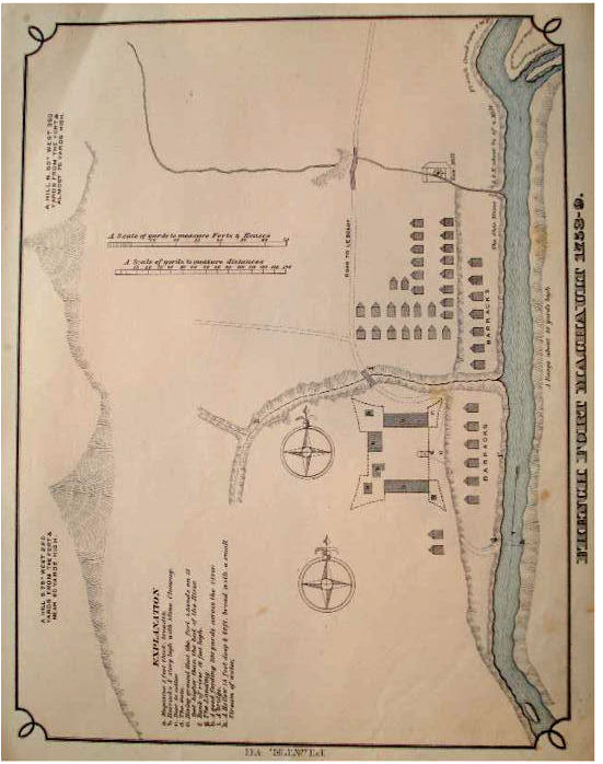
This 1878 map shows the positions of Fort Venango, Fort Machault and
Fort Franklin at the confluence of French Creek and the Allegheny
River, at what is now the city of Franklin, Pennsylvania. Fort
Venango's design is detailed in the diagram on the left.
http://www.explorepahistory.com/displayimage.php?imgId=1653
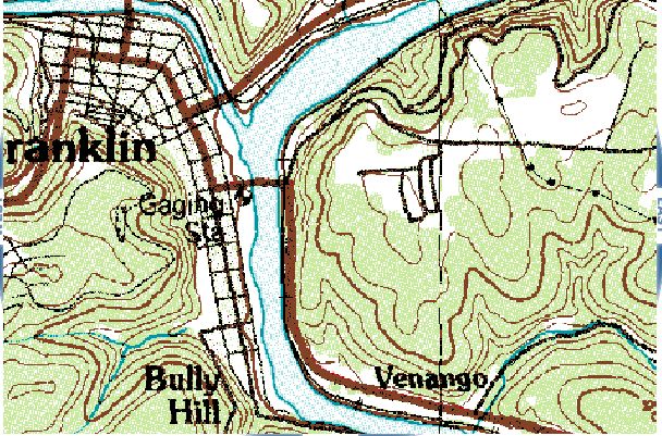
From Terraserver-usa this is the location described on the marker:
Ed Frank
July 1, 2009
I live on the river on Elk street on the 600 block. Aperson has
to
understand the river before building a structure. Fort Machualt
was
here way before Kinzue Dam in Warren. Even today with the dam
the park
at the french creek/Allegahany floods every year. There is no
way a
fort or anything else could have survived there. It had to be on
the
high ground further down the Allegahany. I believe my house sits
on
the remains of the fort.
Tim Lyons
http://groups.google.com/group/entstrees/browse_thread/thread/16593f84768127e0?hl=en
|