WNTS Trip Report – Central
California, Tehipite Valley – June 1972
In a departure from previous Trip Reports I have submitted, I am incorporating images taken by another individual. Those few I took in the 1970’s were not of suitable quality. Not surprisingly in the ensuing 30 years, others have ventured to Tehipite Dome, and have put quality digital images on the Internet. Unless otherwise indicated, the images that follow were taken in mid-October of 2007, by Bob Burd, an avid climber who specializes on ‘dayhike climbs’. His work can be seen at www.snowburd.com/bob. His illustratory contribution is here gratefully acknowledged.
As a Forestry student at Humboldt State University, I worked summers as a forest technician to support my tuition, board and room. So it was, in between the end of spring semester and enroute to a summer job with the Forest Service, my friend David Yeakle and I ventured south from Humboldt to a trailhead in the Sierra Nevada mountains that was to take us to Tehipite Dome, after some 13 miles of hiking.
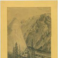
Tehipite Dome, as drawn above by John Muir (courtesy of www. digitalcollections.pacific.edu/cdm4/ item_viewer.php and captured in black and white photograph by E.C. Joe (http://vertical20.com/ Tehipite_Dome.html) expertise.
Avid hikers, full of exuberance for the wilderness that we’d found in the Sierra Nevada and coast ranges, we arrived late in the afternoon where we set up a hurried, quick to break camp.
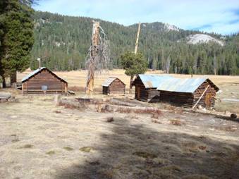
Our trail started at about 5000 feet in elevation, in a classic mixed conifer old-growth forest ecosystem, and proceeded to wind through several vegetation zones before our evening camp near Cow Camp, seen in the image above, at about 8500 feet.
Lush in June, the meadow was still saturated from the winter’s snowmelt, and pack horses grazed there contentedly around the edges. The backside of Tehipite Dome was visible, identifiable from our topographic maps, but not as the sheer monolithic bullet of granite that rose up out of Tehipite Valley at its base.
Between our camp and our ‘quarry’, was Crown Creek which carried a fair amount of snowmelt that we would have to cross. Burd’s image below shows our crossing in October, substantially lower than it was in our June crossing.
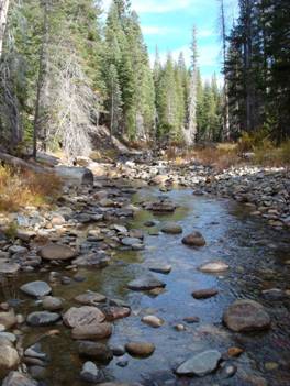
For David and I, with probing staffs, it appeared not to be very deep (2-3 feet), but was numbingly cold. We worked out a strategy that involved the first crosser to have a climbing rope around his waist, using a staff to maintain balance, while the person behind, ‘belayed’ the lead crosser at such a location that should the lead crosser slip, he’d naturally ferry back across the stream at a point the ropes’ distance downstream back on the shore. And likewise, when the lead crosser ‘belayed’ the following crosser, an inadvertent slip would bring about a landing on the far side, a ropes’ distance downstream.
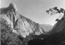
Successfully navigating the stream with rather numb aching calves and feet, we proceeded on our cross-country hike up to the saddle on the north side of Tehipite Dome. The saddle once mounted, permitted an amazing panorama, bounded to the south and east by the Gorge of Despair as it climbed up out of the middle fork of the Kings River Canyon, at this location referred to as Tehipite Valley, and alternatively because of its immense granite expanses and Tehipite Dome as Little Yosemite Valley.

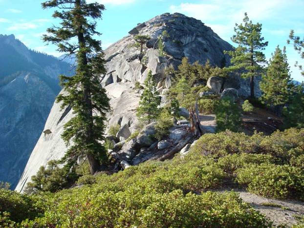
The Tehipite Dome, pictured above from the saddle to the north by Bob Burd, looks much the same as it did when I was there almost 35 years ago. Some 13 miles from the nearest trailhead, with the last several miles a cross-county thrash through fairly dense underbrush, and a treacherous creek crossing, perhaps it will remain reasonably untrammeled.
Naturally, as splendid as the panorama was, the near view of “The Dome” soon captured our attention. We approached it by climbing up out of the saddle, that seemed to get more narrow as we went. Vegetation along the way was grasped as much for assurance as support. Soon our route was blocked by a large slanted boulder some 6-8 feet tall, 8-10 feet wide and perhaps 12 feet long. Either side was already curving down, on the east side about 4000 feet, and perhaps some 300’ on the west side. Neither skilled in free climbing then, and lacking the courage to use the frayed thin yellow polypropylene rope that came across the top of the rock we could see we were less than a hundred feet from “The Dome’s” top. Defeated but not demeaned, we returned to the safety of the saddle and once again viewed the panorama before us.
A closer view of the Dome follows, with two potential routes delineated by Burd…we took the ‘orange route’ preferring to stay ‘on top’, definitely intimidated by the exposure of the ‘magenta route’ along the eastern side. While David had climbing skills, and we had both scrambled comfortably across rock jumbles now famous in Joshua Tree National Monument (now a National Park), we’d never had ‘thousands of feet of exposure’ before. We did have a climbing rope along (used in the creek crossing), but not the advanced skills to proceed without caution. In the end, discretion was the better part of valor, and we were satisfied with our views that follow, quite similar to those of Bob Burd, from the top.
The red rectangle outlines the next image, detailing potential routes taken by Bob Burd.

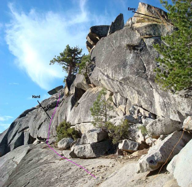
David and I took the route most easily traversed, detailed in orange until the crux of the climb, where the orange route passes over a large granite slab. The following image shows Bob Burd at the crux. David and I both stood there. When we were there, an old frayed and worn polypropylene rope lay across the slab, with a foot or two dangling over the near edge of the slab. Tugging on it, it seemed