==============================================================================
TOPIC: Craters of the Moon National Park, ID
http://groups.google.com/group/entstrees/browse_thread/thread/68bfd317babbd63c?hl=en
==============================================================================
ENTS
In August 2005,
I visited Craters of the Moon National Monument and Preserve
located in south central Idaho.
Craters of the Moon is a large National park It is
over 1,100 square miles (over 750,000 acres) which is roughly the
size of Rhode Island. The
major feature of the park is series of basaltic lava flows that
cover 618 square miles of the park.
http://www.nps.gov/crmo/index.htm
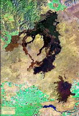
The
young lava flows that make up the bulk of the Monument and
Preserve can clearly be seen from space.
I am a geologist
by training. My focus has always been on soft rock geology.
I am interested in karst features, limestone, fossils,
caves, and vertebrate paleontology. The
bulk of my classes and research focused on these themes, but I had
all the core material on igneous petrology and related phenomena.
I found my excitement building as I crossed the first lava
fields on the way to the park entrance.
The main entrance is located on the northern side of the
monument. This is the
only area easily accessible to the public.
Other areas can be reached through rough primitive roads or
hiking, but on this trip I simply planned on visiting the northern
end of the park.
In addition to the volcanic features are
several unique old growth systems represented in the park.
More about them later.
Geologic
Background
Between
approximately 8 and 10 million years ago, the Yellowstone Hotspot
was beneath Craters of the Moon. A hotspot is a plume of molten or
near molten rock that essentially burns its way through the crust.
The source of the hotspot plume is likely at a depth
of 125 miles or even as deep as the mantle/inner core boundary.
The hotspot is generally believed to be 17 to 18 million years
old, but exactly how they form is not completely known.
The hot spot itself was stationary while the North American
plate slid across plume forming a series of volcanic features.
This early period time was characterized by violent
rhyolite eruptions and caldera formation. Ryolite
is a very viscous form of lava that is generally pinkish in color.
It is the major lava type exposed at Yellowstone and in
places like Mt. St. Helens and other peaks in the Cascade Range in
the Pacific Northwest. The
continents are made of lighter material of granitic composition
while the ocean floors and layers underlying the continental
masses are made of heavier basalts.
These early rhyolite deposits are made primarily of
granitic continental crust material re-melted by heat from the
hotspot and expelled by eruptions at or near the Earth’s
surface. It is more
viscous – stickier – because of high quartz content. Essentially
the continents are the scum that floats on top of the basalts.
Biological materials, including people, are the scum that
live on top of the granitic scum, which floats upon the basalt
that together form the crust of the Earth.
Between
6 million and 15,000 years ago, numerous basaltic eruptions
produced a 4,000-foot-thick sequence of lava flows in the vicinity
of Craters of the Moon. Basalt is made of darker heavier
material and is much less viscous than earlier rhyolitic flows.
That allowed broad relatively flat lava flows to spread great
distances across the land surface. A
prime example of active basaltic flow fields of which everyone is
familiar are the lava flows and volcanoes of the Hawaiian Islands.
Between
15,000 and 2,000 years ago, the Craters of the Moon Lava Field
formed during eight major eruptive periods. During this time the
Craters of the Moon lava field grew to cover 618 square miles. The
Wapi and Kings Bowl lava fields formed contemporaneously about
2,200 years ago. The
lava fields and cinder cones found at the surface of the park all
date from this later period.
The Visitor’s
Center and Campground
My first stop at
any park is the visitor’s center.
They have displays and explanations of the features in the
park. They also have
leaflets and books that provide more details of the features
present. I am a
collector of free booklets, pamphlets, and flyers from the places
I visit. I turn them
into a trip scrap book when I get home.
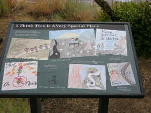
One of the really interesting features of the visitor’s
center area was a series of displays made by school children.
After presentation on the park they drew pictures of
various aspects of the park, the volcanoes, the ecosystem and so
forth. These were
incorporated into a series of signs along a path outside of the
visitor’s center itself.
 photo
by Edward Frank
photo
by Edward Frank
I
have mentioned this previously http://www.nativetreesociety.org/childrens/index_childrens.htm
and have a photo of one of the signs on the page listed above.
This is pretty relevant to discussions of how to get
children interested in the outdoors.
I am sure the sign drawing activities excited those who
participated and their prominent display at the park will also
interest other children who see them.
Kids are interested in activities in which other kids
participate. I wish
Nickelodeon would pick up a show like “Bindi the Jungle Girl”
currently only available in non-basic cable channels.
The campground
is located just past the visitor’s center on the north side of a
modest sized cinder cone. I
set up my tent, pounded the stakes in the loose cinder, threw some
gear into the tent and I was off to see the park
North Crater
Flow
There is a loop
road that leads to the major features at this end of the park.
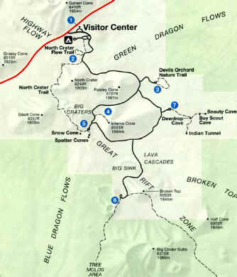
The first stop
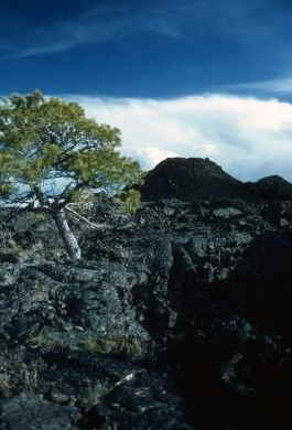
was at the North Crater Flow Trail:
from the website: “At
this first stop a short trail crosses the flow to a group of
monoliths or crater wall fragments transported by lava flows. This
flow is one of the youngest and here the Triple Twist Tree
suggests, because of its 1,350 growth rings, that these eruptions
ceased only 2,000 years ago. You see fine examples of both ropy
pahoehoe lava and a'a lava flows on North Crater Flow. Just up the
road is the North Crater Trail, Take this longer, steep trail to
peer into a volcano vent.”
And “This trail takes you onto the North Crater
Flow, a pahoehoe flow that spilled from the North Crater vent
about 2,200 years ago. Signs along the, trail introduce other
typical features: pressure ridges, squeeze ups, aa lava, and
rafted blocks.” This
was a short hike. There
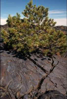
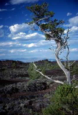
were two feature of note. The
first was ancient Limber Pine (Pinus
flexilis E. James 1823)
tree mentioned above.
 photo
by Edward Frank
photo
by Edward Frank
This is the triple twist Limber Pine.
Impressive isn’t it?
It is perhaps 8 inches in diameter and snakes along the
ground for maybe 10 feet.
It was dead appearing when I saw it.
Dr. Christopher Earle, of Conifers.org
http://www.conifers.org/pi/pin/flexilis.htm
gives a nice
description of the species overall and comments on this particular
specimens: Maximum
ages- Crossdated ages
of 1,670 years from site ERE in New Mexico, collected by Swetnam
and Harlan; and 1659 years for specimen KET3996 from Ketchum,
Idaho collected by Schulman in 1956 (Brown 1996). Given the fact
that crossdated tree ages are always underestimates because of the
near-impossibility of sampling the tree's seedling growth years,
either of these trees could have been the older, particularly
since KET3996 was sampled about 30 years before the ERE tree.
During a 1994 visit to Craters of the Moon National Monument, I
believe I located KET3996; it was dead, and had been for many
years.’ On the subject of memorable Limber Pine localities
he mentions Craters of the Moon: “Craters
of the Moon National Monument in Idaho, which has numerous groves
and an interesting history. Many ancient limber pines in the
Monument were killed by the Park Service in the early 1960s in a
poorly conceived attempt to eradicate a mistletoe infestation.”
Also of interest on this page is a photograph of the
largest Limber Pine documented, Height 18 m, dbh 222 cm, crown
spread 14 m. Locality: On a ridge S of Snowbird, Utah with a tiny
Dr. Bob Van Pelt for scale.
[
Brown,
Peter M. 1996. OLDLIST: A database of maximum tree ages. P.
727-731 in Dean, J.S., D.M. Meko and T.W. Swetnam, eds.,
"Tree rings, environment, and humanity." Radiocarbon
1996, Department of Geosciences, The University of Arizona,
Tucson. ]
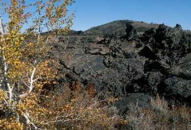
The other major
sight to see on this short trail, are fragments of the edge of a
crater that were broken free and swept down by the lava flow.
A variety of lava flow features are present.
Two lave forms are [resent in this area:
1) Pahoehoe lava is a thin ropey looking form with a
relatively smooth surface; 2)
A’a lava is another
type that has a blocky or chunky appearance, Both are present
along the trail, The
park includes a number of distinct ecological communities based
upon the substrate.
 Limber pine on Blue Dragon - NPS photo
The
open basalt flows represent one of those community types.
The park website reads:
“The types and density of vegetation vary considerably
and depend on such factors as geology, availability of soil and
water, aspect, air temperature, and exposure to wind. The density
of vegetation on lava flows depends primarily on the amount of
soil available. Although lava flow surfaces support only lichens,
vascular plants are able to grow in depressions on those surfaces.
When basalt rock is very young, the only soil available is
whatever blows into cracks and fractures. As soil develops within
these cracks over time, vegetation can begin to grow. The depth of
crevices, cracks, and depressions fixes the amount of soil and
moisture that can be held. The size of the crack also determines
the types of plants that will grow and what degree of protection
they will have from harsh climactic conditions, such as extreme
air temperatures and exposure to high winds.”
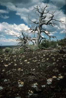
Here you can see plants struggling to grow in tiny
cracks and lichens growing on the rock surface.
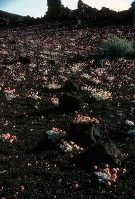
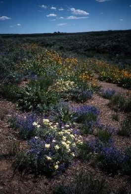
Wildflowers on Cinders - NPS photo |
|
Continuing along
the road toward the next stop several cinder cones are present.
The website reads: “Cinder
cones support three different plant communities: cinder garden,
shrub, and limber pine and/or juniper trees. These communities are
determined primarily by aspect and by succession. In the early
stages of succession, cinder gardens are colonized by species that
produce spectacular spring wildflower displays. As soils develop
on the cinders, antelope bitterbrush (Purshia tridentata)
dominates shrub communities. And on the north-facing slopes where
sufficient moisture is available, limber pine trees (Pinus
flexilis) and/or juniper trees (Juniperus spp.) dominate.”
This trip was in August, so I had missed the spring
flower show, but in some areas numerous plants were present giving
the surface a poke-a-dot appearance.
 photo
by Edward Frank
photo
by Edward Frank
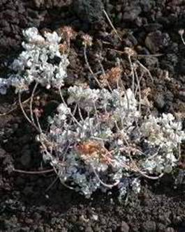
Dwarf
Buckwheat – the tiny flowers can have root systems up to three
feet across
 photo
by Edward Frank
photo
by Edward Frank
The Devil’s
Orchard Nature Trail
“This
paved trail explores an area of cinder beds scattered with pieces
of the North Crater wall. Exhibits along the trail describe the
difficult challenge the National Park Service faces in trying to
protect this fragile volcanic environment. This trail is
wheelchair accessible.”
 Devils Orchard- NPS photo
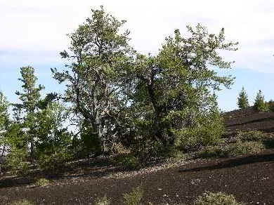
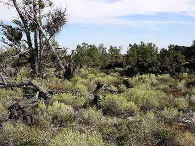
This
was one of the most striking areas of the park.
Intermixed among the lava features were larger specimens of
limber pine. Some
were standing others were the graying remains of long fallen
specimens. Colorful
lichens grew on lava blocks and a variety of other plants grew on
the cinder surface. Yellow
flowered Rubber Rabbitbrush provided color to the scene.
“Rubber rabbitbrush
grows to two meters tall and produces yellowish-green flowers from
July to September. Native Americans made chewing gum by
pulverizing its wood and bark. Rubber rabbitbrush can also be used
to make tea, cough syrup, yellow dye, chest pain medicine, and is
a small commercial source for rubber extraction.”
 photo
by Edward Frank
photo
by Edward Frank
Limber pine and
Rubber Rabbitbrush.
This is an
example of an old growth ecosystem in this climate. The website
reads: “The dominant tree
in the northern half of Craters of the Moon is limber pine (Pinus
flexilis). Limber
pine habitat provides important cover and food for wildlife. The
large, wingless seeds of limber pine have a high energy content
and provide a critical food source for rodents and birds.
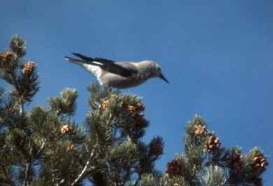 Clarks' Nutcracker - NPS photo
Clark's
nutcrackers are major dispensers of seeds, caching groups of seeds
in the ground. These caches are relocated by Clark's nutcrackers,
pilfered by rodents or are forgotten and germinate under favorable
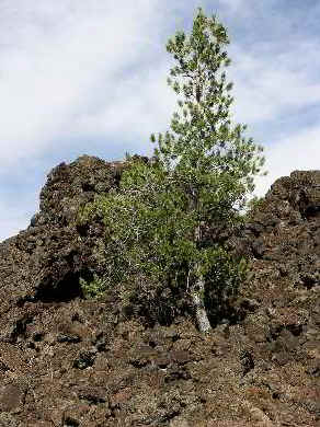
conditions. Limber pines are more abundant on aa than pahoehoe
flows, but in both cases are able to grow where water collects,
and especially where the trees receive protection from the fierce
high desert winds.” One
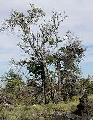
of the notable aspects in this location is the relationship
between the limber pines and the parasitic species of limber pine
dwarf mistletoe (Arceuthobium
campylopodum forma cyanocarpum. )
It is parasitic almost entirely on five-needled pines,
especially Pinus flexilis.
Mistletoe infections are extensive on limber pine in this Park
Unit, even on trees of the most interior lava fields.
Limber pine is a native species locally common across
large areas of western United States.
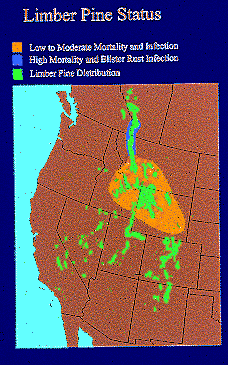
Distribution of
the Limber Pine http://nrmsc.usgs.gov/research/limber.htm
The park website
describes these two important species Limber
pine is “a species generally occurring in forests or ridgelines
at greater elevations in Idaho, it is also at home on lava flows
and cinder cones, to where it is largely restricted in this Park
Unit. It has five needles per fascicle, and its branches are
limber enough to be bent into a “U” without breaking! The
limber pine at CRMO are characteristically odd-shaped, twisted,
and bent due to a combination of harsh environmental conditions
and infestations of dwarf mistletoe “
 Limber Pine Snag - NPS photo
“Dwarf
mistletoes are dioecious stem parasites of plants in the families
Pinaceae (pines) and Cupressaceae (junipers). They are not leafy
or green but are somewhat photosynthetic. They often cause the
infected tree to produce swollen limbs called “witches’s
brooms.” Mature fruit can be projected with force over
considerable distances from the plant. Regrettably, the
eradication program of mistletoes in the 1960’s brought about
the cutting down of
many
old and ecologically important conifer trees; such a program is
discouraged today.”
 Dwarf Mistletoe on Limber Pine - NPS photo
The note above
and following is a brief statement which includes the only
reference or information I could find about a hideous decision
made by the National Park Service in the 1960’s:
“Dwarf mistletoe
and white pine blister rust are two primary causes of concern for
ecosystem health at Craters of the Moon National Monument. Both
affect limber pine stands, which account for over 95 percent of
the forested acres in the monument. Dwarf mistletoe (Arceuthobium
spp.) is a native infectious parasitic organism that establishes
itself on hosts such as limber pine trees. In general, dwarf
mistletoe reduces the vigor and growth of infected trees by
appropriating water and nutrients, and disturbing the normal
physiological processes of the tree. Heavy dwarf mistletoe
infections increase the susceptibility of the trees to attacks by
bark beetles and to system failure from environmental stresses. In
some cases, they can kill the tree by slowly robbing it of food
and water. Death occurs slowly in most cases and depends on the
severity of infection and on the vigor and size of the tree. Dwarf
mistletoe has a relatively long life cycle between infection and
seed production (six to eight years), which allows for long-term
disease management. Management
and control efforts in the 1960’s were unsuccessful and resulted
in the removal of 6000 limber pine trees. Today, dwarf
mistletoe is recognized as a natural parasitic organism that has
been a part of the Craters of the Moon limber pine ecology for
hundreds to thousands of years. It has become an issue of “which
is worse, the disease or the cure?”
 photo
by Edward Frank
photo
by Edward Frank
This is a prime
example of managerial “doublethink” with more than a trace of
Orwellian overtones. They
were going to save the forest by cutting down the trees.
In fairness the Park Service in the 1960’s was often
populated by people involved in the production forestry.
To those of the production mindset, a tree was simply a
crop to be managed and harvested without any intrinsic value of
its own. But still,
even though over time there has been a shift in conceptual
differences about the importance trees as part of an overall
ecological system, I can’t see how anyone could have thought
that cutting down these trees was a good thing to do.
[There is a quote I can’t quite remember, perhaps by a
Russian novelist, and I am sure I am mutilating it, but it says in
effect: “The
decision was without flaw or the possibility of error, because it
was the result of official action, and not subject to the
fallibilities of an individual man.” -
help me out here] I
have searched the internet for information about this management
decisions without any success.
You can find almost anything on the internet, but this
somehow has not been included.
 photo
by Edward Frank
photo
by Edward Frank
A
limber pine tree infected with dwarf mistletoe.
The mistletoe results in part in the formation of the
witch’s brooms that appear prominently on the right side of this
tree.
The question
beyond “What were they thinking?’ is what affect did these
tree removals have on the ecosystem of the park?
The trees form a core of the ecosystem.
They provide shade for other plants and animals.
They introduce large amounts of organic matter into the
system through needle loss and through decaying wood eventually
when they fall as coarse woody debris.
Fallen trees serve and windbreaks and a place where wind
blown sediment can accumulate.
The removal process itself likely
damages the areas around the trees, and in an environment where
existence is a struggle any disruption can have long trerm
effects. From a
scientific and aesthetic standpoint, you must ask how many
millennium old trees were cut in an effort to “save” them?
How many of those trees would have survived for centuries
more if they had just been left alone?
The damage is incalculable.
Inferno Cone
The Inferno Cone
lies along the inside of the road loop.
It has a trail that leads steeply up the side of the cinder
cone. From the top
you can see
panoramic views of the entire park, Great
Rift, Snake River Plain, and Pioneer Mountains. On clear days you
may see the Teton Range, 100 miles to the east.
The view from the top is spectacular.
 photo
by Edward Frank
photo
by Edward Frank
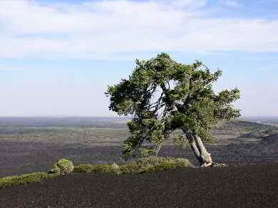
Atop
the Inferno Cone stands a lone pine bent by the wind.
It was here that
my camera bit the dust. I
set the camera on the tripod and planned on using the timer to
take a photograph of myself beside the lone pine tree.
Just as I backed away, a string gust of wind blew the
camera and tripod over. The
camera did a face-plant in the cinders and stopped working.
This was the end of my photographic documentation of the
park.
 Spattercone - NPS photo
Beyond the
Inferno Cone are a series of other stops.
The next stop is at two small spatter cones.
Once pristine, these cones have been loved almost to death.
The cinders forming the cones are poorly consolidated and
have been broken down by visitors tramping upon them.
Currently there is a paved path up around the side of each
of the cones, and mesh fencing keeps people from venturing in the
throat of the cones at the top.
So they are being protected now to minimize future damage
to the volcanic forms.
The next stop on
the tour leads to the Broken Top area.
A spur road just
past Inferno Cone leads to this trailhead. Here you can view the
imprint of lava-charred trees alond the Tree Molds Trail (2
miles). Broken-Top Trail (self-guiding) circumnavigates a cinder
cone (1.8 miles). The Wilderness Trail leads to molds of upright
trees called lava trees (4 miles) and the vast wilderness area
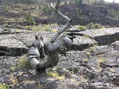
beyond. Of
particular interest at this stop are the lava mold plant fossils.
In a rare example of
fossils preserved in igneous rocks, dozens of tree mold
impressions are preserved in the basaltic lava flows and in lava
tubes. These impressions were formed as lava flowed around a
fallen tree. The molds typically show shrinkage cracks. Moisture
in the wood may have prevented incineration of the trees.
The next stop
leads to a series of short trails leading to a number of lava tube
caves. These form
when the outer surface of the lava flow cools and becomes solid
while the interior lava still molten continues toflow leaving
behind a lava tube shell. The
website notes that the Caves at Craters of the Moon represent
Pleistocene or Holocene basaltic lava tubes. The number of
documented caves currently exceeds 300, and with further
exploration and inventory a realistic estimate of the number might
exceed 600. Of these
a few are open to the general public.
A good external link on lava tube caves is found at:
http://goodearthgraphics.com/virtual_tube/virtube.html
A virtual Lava Tube Cave tour with definitions by Dave
Bunnel. Caves you can
visit include Dewdrop Cave, Indian
Tunnel, Boy Scout Cave, and Beauty Cave.
Indian Tunnel is a through trip.
You climb down a ladder into the cave, work
your way through, and come out another entrance at the far end.
From here you can follow a trail marked by cairns back to
the original entrance. The
lava surface itself is brittle, almost like a rock foam.
Off trail foot travel has damages the surface in many areas
of the park. The
pressure from your footstep breaks the thin shell on the surface
of the rock. In a
short time this material will oxidize and form a rust colored mark
on the ground surface. One
thing you need for exploring these short caves is a good light.
A regular flashlight just doesn’t make enough light to
let you see much beyond your own feet as the black walls suck up
the light. I worked
my way through a couple of the caves this way, but I could not
really see anything of the cave shape or structure.
The solution I found back in my vehicle.
I pulled out my rechargeable 1,000,000 candlepower
spotlight. This proved to be the ideal size of light for these
explorations, and I revisited all of the caves open in the area.
Inside many of these caves, even in August, was cold with
masses of ice still lingering in the back corners of the chambers.
It was getting
dark, so I headed back to the campground in a growing wind.
When I arrived I found the wind had rolled my tent over.
The stakes were pulled out of the ground.
A previously damaged tent pole was bent in two.
The only thing that saved the tent from being blown away
completely was the presence of a heavy cooler inside.
I set my tent up again, and took a quick shower.
The night was spectacular.
It was clear and the stars shone brightly.
We were far from the light pollution of any nearby cities
and the crisp desert air seemed to fit the scene.
After a restless night in which my tent kept
bending and flapping in the wind. I left early the next
morning, maybe 5 am local time.
Onward to my next destination…
 Aspens and Lava - NPS photo
Other Features
– Old Growth Junipers
Aside from the
limber pine old growth there are a number of other significant
ecosystems in the park that are worth considering and documenting
should I visit again. The
website notes:
“In
the southern portions of the monument, stands of Rocky Mountain
juniper (Juniperus scopulorum)
and Utah juniper (Juniperus osteosperma)
provide scarce structure and food source for birds and other
wildlife. Although many were harvested by early settlers, some
rare stands of old growth junipers (700+ years old) remain on the
lava fields.
A
few other species of trees are also found here, but in very
limited numbers and geographical areas. The portion of the
monument north of U.S. Highway 20/26/93 contains some Douglas-fir
and upland quaking aspen stands. Douglas-fir forests are found on
the relatively steep, north-facing slopes of older cinder cones
and along Little Cottonwood Canyon. Quaking aspen groves are in
upland sites away from permanent stream courses.
Several
shrubs typically associated with mountain or riparian habitats are
uniquely able to find similar growing conditions in the cracks of
barren lava flows at Craters of the Moon. Examples include the fern
bush and syringa. In order to resist being robbed of moisture by
wind, the fern bush (Chamaebatiaria
millefolium) grows
inside deep crevices in the lava. It has aromatic leaves that
resemble the fronds of ferns and that contain an oily substance
which also helps the plants retain moisture. Native Americans
rubbed the leaves over their bodies to repel insects. Deep
crevices in the lava flows also provide the soil, moisture, and
lower temperatures needed for the syringa (Philadelphus
lewisii) plant to
grow. Named after Meriwether Lewis of Lewis and Clark fame, this
medium-sized shrub bears numerous large white flowers with four
petals. It is very fragrant and serves as the state flower of
Idaho.
Other
common shrubs include sagebrush, antelope bitterbrush, and rubber
rabbitbrush (Chrysothamnus nauseosus).
The
dominant species of sagebrush in the northern part of Craters
of the Moon is mountain big sagebrush (Artemisia
tridentata
ssp. vaseyana),
which is part of a sagebrush steppe ecosystem that includes
different types of grasses. Basin big sagebrush, Wyoming big
sagebrush (Artemisia
tridentata spp. wyomingensis),
three-tip sagebrush (Artemisia tridentata spp. tridenta),
low sagebrush (Artemisia
arbuscula spp. arbuscula),and early
low sagebrush (Artemisia arbuscula spp.
longiloba) are
also found here.
Antelope
bitterbrush provides browse for mule deer during the summer
months, is a frequent host of thousands of tent caterpillars, and
is identifiable by abundant yellow flowers and small, three-lobed
leaves.
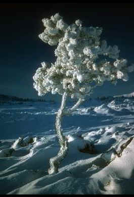 Ice Covered Limber Pine - NPS Photo
Kipukas
Kipukas
are islands of native vegetation that have developed on old lava
flows surrounded by newer flows. Some kipukas in the monument have
been protected from alteration by areas of rough lava and
represent rare examples of undisturbed shrub steppe habitats.
Dominant kipuka vegetation includes three-tip sagebrush (Artemisia
tripartita),
big sagebrush (Artemisia
tridentata),
bluebunch wheatgrass (Elymus
spicatus),
and needlegrass (Stipa
spp.).
Searing
lava flows that initially destroyed everything in their path today
protect the last refuges of intact sagebrush steppe communities on
the Snake River Plain. These islands of vegetation, known as
kipukas, provide important examples of what is
"natural".
These areas are
being invaded currently by some non-native grasses.
Evidence indicates that these kipukas were never grazed and
represent the most intact shrublands in western United States.
The only activity that took place prior to the
formation of the National Preserve were an occasional visitor, and
earlier hunting parties by the native Shoshone.
Shrublands
The
most common vegetation type in the Intermountain West can be
called sagebrush steppe, sagebrush grassland, shrubland, cold
desert shrub, or simply western rangeland.
 Wildflowers in Sagebrush-Steppe Community - NPS photo
Although there are
differences in these terms and in the vegetation communities they
describe, the common component among them is the presence of
shrubs. A particular shrub called sagebrush dominates many of
these communities, and occurs in combination with complex mixtures
of other shrubs, grasses, and forbs. Climate, soil conditions,
parent material and topography determine the general distribution
of sagebrush and the various characteristics of shrubland
communities. The dominant species of sagebrush in the
northern part of Craters of the Moon is mountain big
sagebrush. Mountain big sagebrush is widespread throughout the
monument and is found in combination with the following types of
grasses: bluebunch wheatgrass, Sandberg bluegrass, needle grasses,
Idaho fescue, and cheatgrass. The five other species of sagebrush
found at Craters are basin big sagebrush, Wyoming big sagebrush,
three-tip sagebrush, early low sagebrush, and low sagebrush. Other
common shrubs at Craters are antelope bitterbrush and rubber
rabbitbrush. These two species are especially common on cinder
cones. Sagebrush becomes a common vegetation component in areas
with older substrates (geology) and where adequate soils have
developed. The sagebrush steppe ecosystem provides an important
watershed and valuable habitat for wildlife at the monument,
including sage grouse, mule deer, pronghorn antelope, songbirds,
and small mammals. Management protection afforded by the area’s
wilderness status, along with the natural protection the
surrounding barren lava flows provide, help keep many of the
monument’s plant communities in pristine condition.
Edward
Frank