| Lower
Jerry Run Natural Area |
Ernie
Ostuno |
| Jul
26, 2004 03:14 PDT |
Lower Jerry Run Natural Area is located deep in the Elk State
Forest in
Cameron County, PA. On my first visit to this site on 6/26/99, I
found
only a small stand of a few big trees. When I returned on
4/20/00, I
found the rest of the old growth. Here are my notes:
Two separate sections of old growth occur here. The first is a
very
small patch of old trees, only an acre or two. This small stand
consists
of about a dozen big hemlock and two big white pine surrounding
a spring
at the head of a creek (the beginning of the western fork of
Lower Jerry
Run). An old railroad grade goes right by the big trees. The
surrounding
area was completely cut over and is now second growth hardwoods
(lots of
maple). Some second growth hemlock adjoins the big trees to the
north.
They are surrounded by old stumps that show evidence of fire.
One mile
east is the main section of old growth; about 20 acres of
hemlock and
white pine. Curiously enough, the railroad grade from the first
area
follows the northern edge of a ridge right though the second
area of old
growth. Scattered big hemlock and white pine can be found in in
the
valley of the eastern fork of Lower Jerry Run. The ridgetop
between the
two areas is primarily mixed oaks and other hardwords, which may
be old
growth. If so, this would greatly increase the total acreage of
old
growth here.
It is always fun to speculate on why areas of old growth were
left
standing. The William Penn-era laws of paying triple damages for
cutting
someone else's trees explains why surveying errors along
boundaries of
competing lumber companies left some pie-shaped patches of old
growth.
Another reason could be that small sections of forest were used
as shade
and shelter for the logging camps, and the trees were left
standing when
the camp packed up and left. Or an economic downturn might have
caused
logging operations to be halted. I think a combination of the
two last
reasons may responsible for the patchwork of big trees at Lower
Jerry
Run. The small patch of a few big trees was left standing as
shelter,
while the larger stand of hemlocks and pine may have been
abandoned when
the lumber market temporarily went bust. The remoteness of the
location
meant that once the camp and railroad were packed up, it
wouldn't be
profitable enough to come back and cut 20 acres of big trees.
Here's the Pennsylvania DNR site:
http://www.dcnr.state.pa.us/forestry/oldgrowth/jerryrun.aspx
|
| RE:
Dale Part 2 |
Ernie
Ostuno |
| Jul
26, 2004 15:27 PDT |
Lower
Jerry Run NA...
Yeah, you gave a good description of Johnson Run. And yes, there
are a
few beautiful examples of old growth sycamore in there. The only
similar
looking sycamores I had seen prior to the big ones at Johnson
Run were
in town parks! It is strange how such an undisturbed area is
bordered by
what looks like a narrow gage railroad grade, isn't it? |
| Lower
Jerry Run Natural Area |
Dale
J. Luthringer |
| Sep
24, 2004 08:16 PDT |
ENTS,
I made it out to Lower Jerry Run Natural Area on 8/9/04. This
place is
really out in the boonies. I walked a number of miles and still
didn’t
see all of it. Lower Jerry Run is located in Cameron and Clinton
Counties Pennsylvania and is part of the Sproul State Forest.
Portions
of the Lower Jerry Run Natural Area are adjacent to Bucktail
State Park
and the Quehanna Wild Area. Lower Jerry Run is a tributary to
Sinnamahoning Creek which in turn is a tributary to the West
Branch
Susquehanna River. This natural area is also in prime
Pennsylvania elk
habitat.
http://terraserver.microsoft.com/image.aspx?t=2&s=14&x=233&y=1428&z=17&w=1
185 km NE of Pittsburgh,
Pennsylvania, United States
There are a number of different access points to this site, but
there
are no designated trails here. I decided to take the high ground
for my
first trip. I thought of coming in from the bottom of this
watershed
and working my way upstream, but the easy access at the bottom
is
blocked by no trespassing/posted signs. I may decide to skirt
the
boundaries on a future trip, but I’m not willing at this point
to put in
the extra miles that this would take. Coming in from the top end
was
tough enough. I decided to park on a dirt road towards the
southern end
of Lower Jerry Run (LJR) and access the eastern trib first in
search of
old growth. There is a large powerline right of here and I chose
to use
a camp access road to cut right into the top of this eastern
trib.
Bruce Kershner and Ernie Ostuno found some small plots of old
growth in
here, and were very kind to give me a heads-up on where to go .
I was
very curious to try to see as much of these areas as possible on
my
first trip.
As I crossed the powerline via the camp access road, I was
greeted by a
short “buzz” in the royal fern and blueberries just off the
road…
timber rattlesnake! This was a true testament of the wildness of
this
area that I was about to explore. The camp road ended at a camp
about
200 yards north beyond the powerline. The beginning of the east
branch
of LJR was right behind this camp. I hopped the branch on
continued
downstream upslope on its western side. I continued on this
contour for
about 1.5miles until I came to where the east and west branch of
LJR
joined together. The hillsides were very steep here with about
140ft of
relief from hilltop to stream bottom.
There is a small patch of ancient hemlock at this juncture on
the
hilltop that appears to have been selectively cut of other
species.
41 15.731N x 78 4.149W
An old logging road of sorts cuts through this site and wraps
around in
a type of horseshoe around the land contour. I came into this
section
downslope about 60 vertical feet from the top (1/2 mile from top
of
slope) since I was scanning for big/tall trees in the bottom of
the
eastern branch (none that I could see). When I got to the apex
of where
the two branches came together, I spent most of my time scoping
out the
western slope which appeared to be more impressive. Old hemlock
appeared to go up the slope and around the bend back in the
direction I
came from (east side of branch), but I did not take the time to
investigate. Hemlock heights here were in the 115-120ft range.
I’d
estimate some of the older ones to go over 250 years easy. Red
maple
was prominent throughout the area.
I chose to follow this old logging road as far as possible up
the
eastern side of the western branch of LJR to attempt to find
Ernie’s
other small old growth plot at the beginning of this branch. Old
hemlocks continued along the logging road bench for about
another ¼
mile, then stopped abruptly. Forest type changed into distinct
2nd
growth from here on. Ernie, I’m still not sure about the
ridgetops… I
followed the old logging road until I couldn’t see it anymore,
then
dropped down to the stream and followed it until I ran out of
water. I
found the springs where the stream started and looked up, Bingo,
the
small patch of old growth was right where you said it’d be.
41 15.492N x 78 4.571W
There were about a half dozen very old hemlock here, ~350 years
plus,
along with some old chestnut oaks. The old logging road went
right
through this tiny site and ended at another hunting camp about
¼ mile
off. Hemlocks in this site were about 90-95ft high, along with a
decent
girthed white pine to about 80ft. The ridgetop
here was a twisted mass
of mountain laurel. I was running out of daylight by this time
and
decided I better start to bushwhack my way out.
I walked to the camp and followed an access road for about ½
mile, but
it was taking me directly away from where my vehicle was. So, I
mapped
out another route that cut across the flat hilltop back towards
the
right of way and my vehicle. No old growth on this part of the
flat.
Lots of sassafrass and thigh high royal fern… couldn’t help
but think of
all the rattlesnakes that could have been nestled nearby. Gnats
were
viscous when you stopped, hungry for moisture wherever they
could get
it, mostly in your eyes and nose.
By the time I got back to the vehicle, I figured I walked about
5 miles
and confirmed two small old growth plots in some of the wildest
terrain
I’ve been in Pennsylvania. Bruce has noted a couple of other
old growth
sites on or just below various drainages and ridgetops in this
area, but
that will have to wait for another day. I scoped out the bottom
of LJR
where it flows into Sinnamohing Creek from the opposite bank,
north side
of the stream, from RT555. It was a nice view looking up the
watershed,
but appears that this private property section harbors no old
growth
here.
The days tally as follows:
Species CBH Height Location
Comments
Am. chestnut N/A branch
juncture
downed snags
E. hemlock N/A 90.4 W
branch spring
E. hemlock 9.6 96.5 W
branch spring very
old tree
E. hemlock 8.8 115.5 branch
juncture
E. hemlock 7.6 118.4 branch
juncture
Mountain maple 1.4 25.5 W
branch spring personal
tallest find to date
Red maple 7.9 99.2 branch
juncture
White pine 7.2 109.9 branch
juncture
logging road
White pine 8.9 79.8 W
branch spring
All in all, a very good day in a very wild place.
Dale
Also,
A quick review of this site can be found on the following website
produced by the Pennsylvania Bureau of Forestry:
http://www.dcnr.state.pa.us/forestry/oldgrowth/jerryrun.aspx
|
| RE:
Lower Jerry Run Natural Area |
Ernie
Ostuno |
| Sep
29, 2004 21:31 PDT |
Nice job, Dale. You sure are a trooper...it took me two separate
visits
to cover all the ground you walked. The small stand of old
hemlocks to
the west I found the first time out, and I was quite
disappointed
thinking that this was all there was to this site. I still
wonder about
that wooden building near there. Who built it and why? Did you
notice
how low the roof is and how small the doors are? I thought it
might be
an ice house for storing blocks of ice in the summer...but it's
so
remote and there are no large bodies of water nearby.
The eastern fork has more old trees and it's probably best to go
there
when the leaves are down. I went in April and it was easier to
spot the
isolated big conifers on the slopes. I gained access the same
way you
did, from the hunting cabin near the power line clearing. This
place is
certainly remote, and probably only Dutlinger and Mount Logan
Natural
Areas are harder to reach. There's a strange patchwork of young
and old
trees here. My theory is that cutting was underway when the
building
market went bust. Maybe the financial panic of 1893 or 1907 put
an end
to the logging operations? I saw only one decent intact stand of
hemlocks and that was the one you saw near the junction of the
two forks
of the stream. It didn't look like there were any big trees
beyond that,
further downstream on the way to Sinnamahoning Creek, but I
didn't walk
it so I can't say for sure.
Questions:
Was that 109.9 foot white pine right near the edge of the old
logging
railroad grade? I recall seeing one of the biggest white pine
there.
Ernie |
| RE:
Lower Jerry Run Natural Area |
Ernie
Ostuno |
| Oct
05, 2004 15:26 PDT |
Dale,
The old wooden building with the low walls was only a few
hundred feet
west of the springhead of the west branch, where the small patch
of old
hemlocks was. I thought you saw it since you mentioned a hunting
camp
near there, but you could be referring to something else. There
is a
really poor access road to the building from Three Points Road:
http://www.dcnr.state.pa.us/forestry/stateforests/images/elk6.gif
Look for the intersection of Three Points Road and Sand Rock
Road on the
map, just SE of the southern end of the Natural Area. The dashed
road
heading north from that intersection branches off to the east
and ends
at that building. From there you can walk into the Natural Area.
This
road was unmaintained and in very bad shape. I recall almost
bottoming
out with a Dodge Durango.
Yep, that white pine was exactly the one I was thinking of.
There were a
couple similar white pines (or maybe even a little bigger)
further south
of there on the western slope of the ridge, but the older white
pine
seems to have fallen to the axe in this area.
In what part of the natural area were those other old hemlocks
that you
didn't get to? I might take a trip out that way before the snow
flies
this autumn.
Ernie
|
| RE:
Lower Jerry Run Natural Area |
Dale
J. Luthringer |
| Oct
05, 2004 16:38 PDT |
Ernie,
O.K. I guess the hunting camp I was referring to is the same as
the one
you're talking about. Come to think of it, it really was built
quite
odd. Whatever it's original use was, it's definitely used as a
hunting
camp now. I smelled smoke at the camp when I came to that
"springhead"
old growth section, the fire was out but the coals were still
hot. No
one home though. I don't recall many windows (if any) on it
either.
Yes, I see where you came in at. I think I'd have to hoof it in
though.
That road was quite nasty. I'd probably rip the oil or fuel tank
of my
Blazer on that road. I'd prefer not to have to ride high on the
ruts,
my luck I'd get stuck out there. I'm thinking of coming in that
way the
next time on foot, but continue past the road to that camp and
take the
next junction east to walk the point between Middle Jerry and
Lower
Jerry Runs. There's lots of relief here, if it hasn't been
logged for
awhile there may be some big/tall trees here.
Concerning the other older hemlock section, I believe I was
referring to
the end of the east fork of LJR on its western slope. It appears
that
the logging road that wrapped around the point headed south
right into
that area. I initially came in on the eastern fork of LJR, but
was way
downslope from the old hemlocks that appeared to be up near the
ridge
about 1/3 mile up and west of my location. When I was coming
back from
that odd looking hunting camp, I bushwhacked southeast to my
vehicle
towards the powerline right of way. As I came over the flat and
started
back downhill on the east fork side of LJR, I came across
another old
logging/camp access road. This road just might join up with the
one
that you and I have talked about on the east side of the western
fork of
LJR that wraps around the point. This "new" logging
road would be
uphill on the flat, and across the eastern fork of LJR from the
hunting
camp which was adjacent to the powerline where I first started
my hike
(now that sounds confusing...).
Did you explore 'Dark Hollow' yet? It's just outside and west of
the
natural area. I've seen the bottom of it from Jerry Run Road. So
much
area to explore, yet so little time?
Dale
|
| RE:
Lower Jerry Run Natural Area |
Dale
J. Luthringer |
| Oct
04, 2004 07:34 PDT |
Ernie,
Well, you gave me good directions so it saved me a LOT of time.
I
didn't notice any building though... where abouts was it in that
western
section? Bruce Kershner found some other sections of old growth
hemlock
that we didn't see yet. I didn't follow the
logging road around the
contour from a northerly direction to south easterly direction,
or go up
the hill to far since the tree heights diminished considerably
and I still
needed to find the small patch of old growth at the spring.
The 109.9ft white pine was right on the edge of the logging
grade as you
headed from the junction of both branches up the western fork
and just
outside the decent old hemlock section. It was definitely a 2nd
growth
area. I'd put that white pine to ~100 years old.
Yep, mountain maple is Acer spicatum. I've found this
website from
Virginia Tech to be quite helpful:
http://www.cnr.vt.edu/dendro/dendrology/data_results_with_common.cfm
http://www.cnr.vt.edu/dendro/dendrology/factsheets.cfm
Dale
|
| RE:
Lower Jerry Run Natural Area |
Ernie
Ostuno |
| Oct
05, 2004 20:27 PDT |
Dale,
I haven't seen Dark Hollow at all. Do you think there's old
growth
there? Where did Bruce Kershner find the other OG that you
haven't seen
yet? I still have to get that Sierra Club book.
Speaking of books, a few years ago I bought two books about the
railroad
logging era from the PA Lumber Museum up in Potter County. The
books
were published in the early 1970s and the author interviewed a
few old
timers that actually worked for the logging companies more than
50 years
previously. The books are titled "The Goodyears: An Empire
in the
Hemlocks" and "Ghost Lumber Towns of Central
Pennsylvania". They contain
some fascinating history of the era and includes many historical
photos
as well as maps of logging operations annotated with the dates
that
certain areas were logged. The two books are at the bottom of
the page
on this site:
http://www.gearedsteam.com/books/rr-logging-01.htm
Here's a web site that shows some photos from the book:
http://www.steaminthewoods.com/barnhart.htm
One of the rangers of the Elk State Forest also recommended a
book
called "The Story of the Sinnemahone" about the
logging of the
Sinnemahoning River area in the late 1800s, but I haven't been
able to
find it for sale on the net. I did find this reference to it:
http://freepages.genealogy.rootsweb.com/~dundon/media.htm
near the bottom of the page:
"The largest spar was hauled in February 1881.....Ed Dundon
scaled it.
After several measurements and calculations by Scribner's rule,
he said
that it contained fifty-two hundred feet, which put it in the
class of
the largest spars taken down the Sinnamahoning."
Anybody know what "Scribner's rule" is?
Ernie
|
| RE:
Lower Jerry Run Natural Area |
Ernie
Ostuno |
| Oct
07, 2004 23:04 PDT |
Dale,
Yeah I saw the old Shay locomotive and the re-created lumber
camp/saw
mill at the Lumber Museum. That's also where I got the old
logging
railroad books. I thought the bark peelers convention was held
at Cherry
Springs State Park?
I went back and looked at the video I took of Lower Jerry Run
back in
1999 and 2000. I did walk that railroad grade "spur"
that you found when
you crossed the ridge. I also found a small patch of old
hemlock/white
pine on the east slope of the east fork of Lower Jerry Run. Did
you see
those? There were dozens of old stumps all over the east fork
valley.
Ernie
|
| RE:
Lower Jerry Run Natural Area |
Ernie
Ostuno |
| Oct
16, 2004 06:08 PDT |
Dale,
I had forgotten about the old trees on the east slope until I
looked at
the video I had taken. The are fairly easy to get to since they
are not
far from the hunting cabin near the power line clearing. Follow
the east
fork of the creek from there and look up along the east slope.
If you
are able to get back there in the next few weeks after the
leaves are
down, they are easy to spot from the creek. It's only a couple
acres of
old white pine, hemlocks and a few hardwoods. The biggest intact
stand
of old trees I saw were those just upslope of the confluence of
the west
and east forks of the creek, which you saw.
Ernie
|
Lower
Jerry Run Natural Area:
Pass Through |
Dale
J. Luthringer |
| Mar
03, 2005 17:00 PST |
Ed, ENTS,
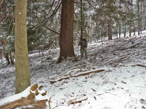
Here is a forward from a super Quehanna Wilderness observer as we were
discussing the location of one of the old growth patches in the Lower
Jerry Run Natural Area in Pennsylvania. Hopefully the jpeg will take.
Ed if it didn't come through, can you post it on the website?
Thanks,
Dale
-----Original Message-----
From: George Lockey
Sent: Wednesday, March 02, 2005 7:44 PM
Dale
I did manage to find the Virgin Timber in the Lower Jerry area. From the
Quehanna Hwy.( they have a sign there for the Natural Area) go 5.65
miles on the Three Runs Rd. You will be at the intersection of the Sand
Rock Rd. There is a parking area there. Across from the Sand Rock Rd.
there will be Orange blazes on a camp road toward the north. Follow this
about a quarter mile to a power line where the trail will turn right.
There is a trail sign there but it is down now. Go two poles and you
will see the orange blazes again, on the left. Follow them to the
timber.
I found one tree that is about 10' 10" in circumference. This tree is at
N41.15.623 W078.04.131. There are a lot of of others that are 8' and
9' in circumference.
The trees are about 8 tenths of a mile from the parking area. You can
drive to the power line and park if you have good ground clearance. It
is an easy walk following the trail, after the snow goes away.
I have attached a picture near the largest tree I found, at the listed
coordinates. The trail goes about 200 yards past this tree and dead ends
at a bunch of trees. It is just a small area of trees, scattered over
about 10 acres?
I hope this helps you find it.
George Lockey
PS your trip to the big trees in Cooks Forest was great. I learned a
lot. I'll be back this summer.
|
|