Hi,
everyone-
Jess Riddle and I recently spent three days visiting the Savage
Gulf State Natural Area in central Tennessee. It is a part of
the South Cumberland State Park system. Savage Gulf is one of
the many steep gorges cut by creeks through the sandstone shelf
of the Cumberland plateau into siltstone, shale, limestone, and
additional sandstone below. The top of the plateau gently
undulates between 1800 and 1900' elevation, in stark contrast to
the steep and rugged terrain of the gulfs. The creeks bottom out
in the park very close to 1000 feet in elevation. In some places
the walls of the gorge can drop from 1800 to 1000 feet in about
1/2 mile. This topography supports some extremely sheltered cove
forests, which apparently can grow pretty tall.
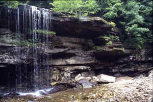 Ranger Creek Falls
The following is excerpted from Tennessee Natural Research Areas
website,
http://www.state.tn.us/environment/nh/natareas/savage/
Savage Gulf is 15,590-acre natural area located in Grundy
County. Carved like a giant crowfoot into the western edge of
the Cumberland Plateau, it is one of Tennessee's most scenic
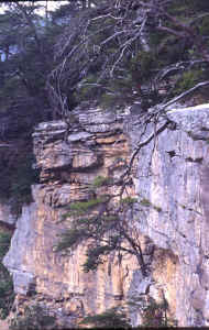
wilderness areas. Its sheer sandstone cliffs and rugged canyons
provide extraordinary views.
Big Creek, Collins River and Savage Creeks each tumble down over
5 miles, dropping over 800 feet through narrow gorges, forming
the "Gulfs."
While much of the gorge is second growth forest, there is one
large section is old growth mixed mesophytic forest in the
gorge. The gorge forests abound with oaks, hickories, maples,
yellow poplars, hemlocks, pines and many other tree species.
Beneath the forest canopy is a vast array of shrubs, vines,
wildflowers, mosses and ferns. Collins Gulf is noted for its
spectacular display of spring wildflowers In the uplands, an old
growth short leaf pine forest is found where red cockaded
woodpecker once nested. Savage Gulf is also on the Departments
of Interior's Registry of National Natural Landmarks. The
natural area is a part of the South Cumberland Recreation Area.
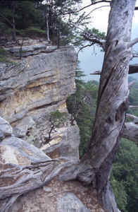 A dead Virginia pine at the edge of a cliff near Stone Door
On the first day, Tom Simpson, the Regional Urban Forester for
East Tennessee, was kind enough to guide us into Savage Gulf .
I'd been in contact with him for over a year trying to get
access into the restricted area of the park, and finally it all
worked out. He brought us into the "Still Hollow" area
of Savage Creek, so named because of the remains of an old still
at the edge of the gulf. Savage Creek runs generally from east
to west, and Still Hollow is one of many small, mostly dry and
unnamed tributaries that descend to Savage Creek, this one on
the south side of the gorge. Savage Creek was at this time of
year also mostly dry, leaving a corridor strewn with massive
boulders where the creek only reaches the surface occasionally.
The Still Hollow area is where Tom had gone in a few years
earlier with some other state foresters to measure some trees
from the state champion tree list. From the top, we picked our
way down the mostly talus covered slopes that form below the
cliffs; these conditions made it hard to walk, but the trees
seemed to like it fine. This north-facing part of the gulf
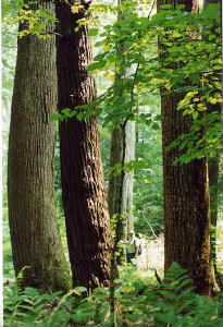
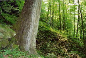
supports a very diverse, healthy, and obviously uncut forest.
The dominant canopy species in this area are tuliptree and
hemlock, with northern red oak (var. rubra), cucumber magnolia,
white basswood (apparently), also occurring frequently, and
shagbark hickories.
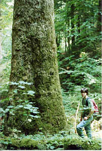 Jess beside the 14 foot cucumber magnolia near Still Hollow
The
hickories here are tremendous; in addition to the more common
shagbarks, we found pignut, mockernut, and bitternut hickories
down in the gorge. Other occasionally occurring overstory
species include beech, yellow buckeye, sugar maple, and closer
to the stream ash (predominately green), sweetgum, and sycamore.
Immediately below that mixed overstory, yellow birch and
yellowwood grew all over the slope. The understory was blessedly
open and mostly rhododendron-free; just a few scattered here and
there mostly either by the creek or below the cliffs. A bit of
mountain laurel, umbrella magnolia, striped maple, spicebush (Lindera),
allspice (Calycanthus), witch hazel, loads of paw-paw and
hydrangea, and even a bit of mountain maple. Sweet cicely (Osmorhiza),
blue cohosh, wild ginger, and stinging nettle frequently
sprouted up between and on top of the forest floor boulders.
The second
day Jess and I hiked a trail across the section of plateau north
of Savage Creek. Forests on the plateau were generally shorter
and gnarlier than the gorges, of course. We did not measure much
of note, but one Virginia pine was 6'11" by 106.2'. An
ancient oak forests survives on the mostly flat terrain. White
oaks are most abundant, but black oak, chestnut oak scarlet oak,
mockernut hickory, and sand hickory are also common along with
pockets of shortleaf pine. While some areas support a mix of
sourwood, American holly, and young white oaks underneath, other
portions had a pure red maple understory. Lots of blueberry,
sparkleberry and azalea in the shrub layer. Adjacent areas of
younger forest were either dominated by a mix of shortleaf pine
and scarlet oak or nearly pure Virginia pine. Virginia pine with
a mountain laurel understory also occurred consistently along
the north rim of the gorge.
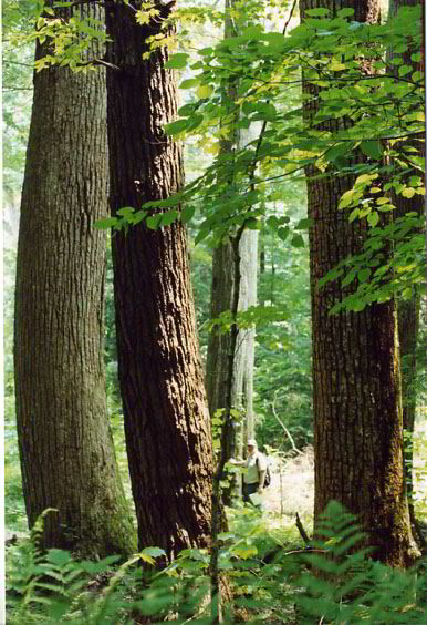
 Tom Simpson in a nice stand of hemlock, tuliptree, and northern red oak
near Still Hollow (a bit of an illusion, but the trees are big)
Tom Simpson in a nice stand of hemlock, tuliptree, and northern red oak
near Still Hollow (a bit of an illusion, but the trees are big)
After checking out
the tantalizingly named "big tree spur trail," which
did have some large and old trees, we headed for the rim and a
path down, thinking possibly we could follow Jumping Water
Branch down. We were stopped when the creek dropped over a
cliff, surprise surprise. Getting down is not easy anywhere
there, but on the north side, it seems even harder, with pretty
consistent cliffs most of the way down the gulf. One spot on the
west side of the branch looked deceptively easy to go down, but
when we got there and realized it was even more steep, Jess
looked more closely at the map and noted how 100 feet of contour
lines got sucked into one line. He suggested a ridge on the
other side of the cove that looked at least possible. Looking
across and at the map I thought he might be insane but didn't
say so, instead saying "I guess we can try". He was
right, though it was about as steep as anywhere I've been and
still involved weaving around a few small cliffs and holding
tightly to some small trees.
 A tipped-over Virginia pine hangs tenaciously to the cliffs.
The
southwest facing cove of Jumping Water Branch also had some tall
trees, but the composition was different, seeming less moist but
still rich. More ash, white oak, a mockernut hickory in the
cove, and walnut joined the tuliptrees and hemlocks. We traveled
down the east side of the cove and over a ridge heading upstream
on the north and dryer side of Savage Creek, where we started
seeing some chinkapin oaks. Jess had found one by poking across
the creek the day before, and it wasn't an anomaly. We crossed
back over to the south side and explored more of the territory
there, until rain chased us under a cliff. Jess had spotted a
huge northern red oak, and when the rain was gone we went back
down and got at least one pretty good shot on it. Tree measuring
in general was very difficult with high tree density and full
crowns of leaves, as well as the topography limiting where one
might measure from. When I got stung by a yellowjacket, I had to
cut the day a little short; I was a little too worried about a
reaction so far in the middle of nowhere, and thunder was still
rolling nearby. Hence, we have only scratched the surface; a
winter trip is a must.
 The 10' cbh by 127.3 foot walnut on Jumping Water Branch
The last day there we went down into Big Creek Gulf. Big Creek
Gulf meanders from the west southwest to the north northwest.
The forest we saw was mostly very different, due mostly to the
gulf there being so much wider and the more southerly aspect of
the slope we traveled on. The fact that it had been logged had
probably changed the composition a bit as well. White oak was
one of the most dominant trees, but there were more sweetgum,
chestnut oak, mockernut hickory, slippery and winged elms,
patches of butternut, and tons more stewartia in the understory.
We took the trail to Ranger Creek Falls, where the slight flow
of the creek drops into a small pool and disappears. It would be
interesting and perhaps more fulfilling to explore the more
sheltered areas of this gulf. Heights in the areas of Big Creek
Gulf that we saw were not extremely tall, but regeneration and
density was impressive.
Here are the numbers:
Species Cbh Height
Ash, Green NA 116.3'
Basswood, ? NA 124.5'
Buckeye, Yellow 14'1" 127.5'
Cherry, Black NA 119.2'
Hemlock, Eastern NA 139.2'
Hickory, Mockernut? 6'4.5" 147.5'
Hickory, Pignut 8'8" 162.3'
Hickory, Shagbark 9'1.5" 140.1'
Hickory, Shagbark 8'9" 146.8'
Hickory, Shagbark 9'0" 150.3'
Magnolia, Cucumber 14'0" ~125'
Magnolia, Cucumber 11'1.5" 133.6'
Oak, Chinquapin 5'7" 117.2'
Oak, Northern Red NA 122.3'
Oak, Northern Red 11'2" 131.9'
Oak, Northern Red 11'11" 144.6'
Oak, Northern Red 14'4" 150.1'
Oak, Scarlet NA 122.5'
Oak, White NA 130+
Sweetgum ~7' ~147'
Sycamore 9'5" 129.9'
Tuliptree 7'8" 150.8'
Tuliptree NA 158.7'
Tuliptree NA 160.0'
Walnut, Black 10'0" 127.3'
Initial Rucker index: 144.99
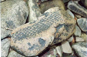 A rock we found in the bottom of Savage Creek with the oddest scale-like pattern
The white oak is at least 130, probably a good bit taller, I got
that height shooting up from three different places, but not
getting too close to the top. There was absolutely no good place
to measure that tree except possibly from atop the cliff above
it. The sweetgum is, I think, 147.2, but I had no paper to write
on and was too far to yell numbers to Tom or Jess at the time.
It's over 147, anyway. Like quite a few of these trees, might be
a little taller also. I think we probably saw taller basswoods,
but never got a good shot.
I think Jess and I would both agree Savage Gulf is one of a
small group of the premier forest sites of the Eastern U.S., and
still has much territory to cover. The uncut and more sheltered
areas of Savage Creek most certainly harbor some other
impressive (and possibly record-breaking) trees. Most all of the
trees here were in a relatively small area of the gorge. From
what we saw, there's no reason a much larger area would not hold
similar if not the same high density of rather large and
incredibly tall trees. The Rucker index will surely go higher
with more visits. The current index is from only a couple of
days worth of measuring. It will be interesting to see what else
Savage Gulf holds for us in it's deepest reaches.
Mike
P.S. I wrote this out and ran it by Jess, who gave a great deal
of good input and detail, so thank him for any thoroughness and
clarity in this report.
|