| Biscuit
Fire: Oregon
Field Guide |
|
photos by National Forest
Service http://www.biscuitfire.com
http://www.biscuitfire.com/facts.htm
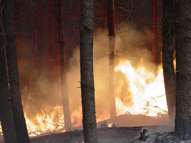
The
Biscuit Fire, located in southern Oregon and northern
California, began on July 13, 2002 and reached 499,965 acres.
Estimated to be one of Oregon's largest in recorded history, the
Biscuit Fire encompassed most of the Kalmiopsis Wilderness. The
boundary of the Biscuit Fire stretches from 10 miles east of the
coastal community of Brookings, Oregon; south into northern
California; east to the Illinois Valley; and north to within a
few miles of the Rogue River
|
| Biscuit
Fire: Oregon
Field Guide |
ror-@open.org |
|
Nov
17, 2003 18:14 PST |
|
Robyn:
An amazing thing happened. I was watching a bit on the Biscuit
Fire on OPB
and I hear this name. What do you know? There you are on the
picture box.
So tell me, what exactly kinda research are ya doin' on the
Biscuit Fire?
I find this stuff very interesting and would love to find out
more. Are
there any good websites out there or anything that tells lots of
facts and
other info about this great fire? About how long ago did they
interview
you?
Rory
Nichols
|
| Re:
Oregon Field Guide |
The
Darbyshires |
|
Nov
17, 2003 22:26 PST |
Hi Rory - yes, that was me on the Oregon Field Guide. I believe
they
interviewed me and did the filming with Crystal Raymond and
Bernard Bormann
in early August. We were surprised that this episode was airing
so soon -
when they filmed it they told us that they were tentatively
planning to air
it next spring!
There is a web site for the fire: http://www.biscuitfire.com
The Draft EIS (Environmental Impact Statement) for the fire
recovery
projects is also available on-line through that web site. Of
course, most
people are interested in the fire salvage proposals, but there
are a number
of other projects included in there as well that involve
reforestation,
prescribed burning, fuel break creation/maintenance, etc. The
major
controversy with the salvage is that there is pressure to
salvage in
roadless areas. My major involvement in that project has been to
take the
lead in developing a large-scale replicated management study to
compare
three different methods for restoring Late-Successional Reserve
areas that
were burned by the fire. The study plan for this project can be
found in an
appendix to the DEIS. The study plan has just undergone a peer
review and
we will be revising the study plan for the Final EIS (FEIS).
Because the Siskiyou National Forest felt that there would be a
lot of
research interest after the fire, I agreed to take on the role
of "Research
Coordinator" in addition my regular job, which involves
coordinating the
research activities on the Long-Term Ecosystem Productivity
Project for the
Pacific Northwest Research Station. We have research sites on
the Olympic
Peninsula (near Forks, WA), in the Oregon Cascades near Vida, OR
(in the
McKenzie River drainage), and in southwestern Oregon near
Brookings, OR.
The primary focus of these sites is to look at the effect of
different
forest plant communities and large woody debris on ecosystem
productivity.
One of the treatments emphasizes early seral vegetation with
Douglas-fir,
another treatment emphasizes Douglas-fir, a third treatment
emphasizes
Douglas-fir with more shade-tolerant species, and a fourth is an
uncut
control. Each of these vegetation treatments has subtreatments
with high
and low amounts of woody debris. We have set up a series of
long-term plots
to measure a variety of attributes of these conditions over
time. The fire
burned through some of them, and we received over $450,000 to
compare the
pre and post-fire conditions on our detailed, permanently marked
plots.
I do have a handout that lists current Biscuit Fire research
projects if you
are interested. It is in Microsoft Word. I'd be happy to email
copies to
anyone who is interested.
Robyn
|
| Re:
Oregon Field Guide |
ror-@open.org |
|
Nov
19, 2003 18:20 PST |
Robie:
To tell you the truth, I often have no idea what I'm talking
about either.
So don't worry, we are in the same boat.
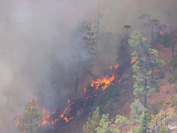
I have to say I often forget about how forest fires really burn.
When I
hear the figure of 500,000 acres it's hard not to picture this
vast area
that were burned to the ground. The local 5 o'clock news paints
it up like
this. But in all reality the Biscuit Fire had about 95,000 acres
(19%)
that went untouched, about 205,000 acres (41%) burned at a low
intensity,
leaving green trees standing and healthy while clearing out
brush and
small trees. Only 15.7%, about 78,500 acres, burned at high
intensity,
leavin little but ash and charcoal behind, and 22.6%, about
113,000 acres,
burned at moderate intensity, where underbrush and most trees
where
killed, but their leaves or needles remained intact.
The fire killed about 53,000 acres of old growth forest
considered
suitable for spotted owl habitat. As of Sept. of 2002, the fate
of 47
pairs of spotted owls is not known.
Rory Nichols
|
|