| Day
#4-part 2 |
Robert
Leverett |
| Aug
21, 2006 06:54 PDT |
ENTS,
First,
a word of appreciation to Lee for his input on loess.
Also, Lee, I have found the mother load of earthworms. They are
in
Monica’s and her neighbors yards. I’m serious. I was cutting
the lawn
when they came to the surface. I had been suspicious of the
texture of
the soil. It looked like earthworm worked over soil and it is.
We don’t
have to look in the woods behind Monica’s house. We’re
swimming in
earthworms. Wait until you see the extent of the local
neighborhood
invasion. HELP!! Now, to the remainder of Day #4.
Bob
Day #4 – Part 2:
Before moving into the Nebraska part of our trip, I’d like to
say a few
words about western Iowa’s Loess Hills to include what the
Loess Hills
are. But first, how do you pronounce Loess? I always flinch when
encountering a new word, the pronunciation of which I have no
idea. For
me, loess was such a word. I originally called it loss with a
long “O”.
However, loess is German and the way we pronounce it today makes
it
rhyme with “fuss”. I don’t think that was the German
sound, but we’re
stuck with the fuss-rhyming version.
The Loess Hills of Iowa run north and south for about 200 miles
following the channel of the Missouri River. The Hills are on
both sides
of the Missouri, but by far the largest deposits of loess are on
the
eastern, or Iowa, side. The predominant material making up the
hills is
a very fine-grained, remarkably homogeneous quartz silt that was
created
by past glacial action. Loess soils exist in many parts of the
world and
are among the richest on the planet, but apparently none are
exactly
like the loess that makes up the Loess Hills. So there are
grades of
loess. That is to be expected, I guess.
If I’ve learned anything in recent years about how our planet
is put
together, it is that the geological processes that are
responsible for
the landforms that we see are seldom obvious to the eye, except
for
surface patterns of water erosion, layers of deposition, and
maybe the
sine-wave warping of rocks sometimes exposed in road cuts and
often seen
in western mountain profiles. Creating a landscape is no mean
task for
nature. The commingling of complex geological processes acting
over eons
belies the simplified explanations that one often reads about
the origin
of a landform as presented in the popular brochures that one
gets at
parks and refuges. For me, these simplified descriptions do
little more
than fill space on a page. Maybe they satisfy the urge for a
quick
information fix, but I’m invariably left feeling unsatisfied.
So, I
avoided the quick fix brochure and bought a book on the Loess
Hills, and
from it, I actually think I understand the basic building and
subsequent
sculpting processes. I’ll talk more about this book later, but
from it
and the copious information available on the Internet, I’m
coming to
appreciate the impact of the Loess Hills on native Iowans and
Nebraskans. What follows expresses some of the sentiment that
the Hills
generate.
ODE TO THE LOESS HILLS
From a Song by Sy Runkel
“There's a land in Western Iowa, where the prairies meet the
sky
And the setting sun paints the hilltops gold before it says
goodbye.
Where the great Missouri River flows on its western shore
And the wild geese by the millions fly their age-old routes of
yore!
That's the place I want to be, in these ancient hills of time
Where I'm at home with the yucca flower and the prairie
dandelion!
So now!
Away, away then I must go!
Up into these hills where the prairies grow.
And nature speaks to let us know the wisdom in a flower! “
A lot of work has been done on decoding the formation of the
Hills going
back into the 1870s. Early theories suggested that slow
deposition by
melting water from the glaciers formed the Loess Hills. That
view
changed a few decades later. The current explanation for the
Loess Hills
is approximately as follows. The last two glacial epochs, the
Illinoian
(130,000 to 150,000 years ago) and the Wisconsinan (with coldest
period
about 18,000 years ago) ground up a lot of rock to the north of
the
Loess Hills. That is one thing glaciers do, i.e. grind up rock
into a
powder. The streams at the south end of the ice sheet ran milky
with
ground-up rock and spread the material far and wide. This became
the raw
material of the Loess Hills. When the land dried out, this
“glacial
flour” was later picked up by winter winds and blown to where
obstacles
caused it to be dumped. The glacial material consisted of
particles of
clay, silt, and fine sand. Winds deposited material into the
late 1800s.
Throughout the period, water carved the modern forms of the
hills. The
water had lots of material to work with. In some places the
loess
deposits exceed 200 feet in depth.
What changed the minds of the geologists from water to wind as
the
principal agent of piling up the material ? Nature historian
Bohumil
Shimek who did much of the early research on the Hills related
accounts
of watching extensive dust clouds lift from the sand bars of the
then
un-dammed, uncontrolled Missouri River and drift into the Hills.
What he
saw confirmed for him his wind-centered theory of the formation
of the
Hills and he changed his view of the origin of the Hills that
once
prevailed – that slow deposition of slow moving water created
the Hills.
Finding the fossil remains of dry land snails at all levels of
the Loess
Hills cinched it for Shimek . The Hills had a wind-driven
origin.
Monica and I did not have time to explore the Loess Hills except
to
climb a tower at a scenic overlook and enjoy the view. As we
stood on
the observation deck looking westward, we beheld the exquisite
blending
of sky with the wavy line of the earth created by the Hills. The
wind at
the top of the deck, the wide horizon, and plentiful sky
reinforced for
me that we were back in the land of vast spaces and distant
horizons.
Yes, we were now in the domain of the wind. John Madson
eloquently
captures the spirit of the prairie winds in his description of
the
difference between wind in grasses and wind in trees:
“I see each oncoming gust before I feel it – advancing
swiftly across
the prairie in a long wave of motion, sometimes escorted by
patches of
cloud shadow that changes the tone and color of the grassland as
the
wind changes the shape. More than in a forest, and even more
than on sea
or lake, it is here that the wind is most visible. The ripening
grasses
bend and winnow, the waves of our air ocean rolling over the
wild
meadows until, as Willa Cather put it,: “The whole country
seems to be
running.”
The wind will enter a distant grove of trees with a roar, for it
resents the oaken strength of trees and shouts and growls as it
wrestles
with them, tossing their crowns furiously. But out here on the
open
prairie that wind only sighs and whispers, passing over the
grasses with
little resistance. The grasses bow to the wind’s force,
acquiescing to
its passage and letting it go unchallenged and undiminished.”
From our vantage point, we could see slices into the Hills where
steep
ravines, cut by water into the silt, suggested that a
fascinating
landscape lay at our feet, begging to be explored, but alas, we
were
westward bound and we had to maintain some semblance of a
schedule. So
we pushed onward.
Our next stop-off was at the Desoto Bend Wildlife Sanctuary on
the
border of Iowa and Nebraska. Desoto Bend is where the Missouri
takes a
huge turn and it is the location of a famous steamboat wreckage.
It was
that of the Bertrand, a state-of-the-art steamboat built in
Wheeling,
West Virginia. On that fateful day of April 1st, 1865, she was
headed to
the gold fields of Montana. It was her maiden voyage and spirits
were
high. However, on reaching Desoto Bend, she hit a snag and
promptly
sunk. The sinking occurred so quickly that none of the cargo
could be
rescued. Fortunately there was no loss of life. Despite the
heavy
financial loss, the Bertrand’s fate did not deter steamboat
travel on
the Missouri. It was not at all unusual for steamboats on the
Missouri
to sink. A staggering 400 met a fate similar to the Bertrand’s
in the
turgid waters of the “The Big Muddy” often accompanied by
significant
loss of life. On hearing of these losses reminded me of how
dangerous
travel in those days was. There were hostile Indians (and
rightfully
so), severe weather, disease, fatigue, snakebite, malnutrition,
and
heatstroke, to name a few.
Over just a few years, a major shift in the course of the
Missouri left
the Bertrand buried under18 feet of silt and for a century
nobody could
figure out where it was. It was eventually uncovered by two
persistent
researchers, intent on solving the mystery. But that didn’t
occur until
1968. In the interim, the contents of the Bertrand were
perfectly
preserved and are now on display at a museum at Desoto Bend in a
climate-controlled, glass-enclosed display room. All the items
on the
boat were intended for the Montana mining boomtowns. You can’t
imagine
how many belt buckles they required. Women’s lace, mining
tools, wine,
you name it. It is all there to see.
Before resuming
my description of our trip, I’d like to take a
small detour and relate a story about the Bertram from around
1997, as I
recall. Mike Perlman and I were returning home from a trip to
Cook
Forest, when we decided to detour from our planned route that
followed
I84 east from Scranton, PA. But near the border of PA and NY, we
had
enough of the Interstate. We decided that it was time to meander
and so
we swung northward onto the network of rural roads. The
back-road jaunt
was delightful when both of us realized that the rumbling sounds
we
heard weren’t thunder, but our stomachs. It was time to eat.
We eventually reached a small, sleepy town, the name of which
I’ve
forgotten. We looked for an acceptable spot for a late lunch and
found
one. The restaurant was a diner of sorts, but one with a
clientele I
suspect that was local and loyal to the owner. The diner was
immaculate
and thankfully had none of the standard trappings of the spots
that
cater to the majority of Interstate travelers accustomed to
corporate
decor. We soon observed that the owner was into all kinds of
memorabilia, which he artfully displayed around his diner. He
was
obviously a person of pride and wide interests. Mike and I chose
a table
and sat down. The table was located near a load-bearing column
for the
building. We ordered and proceeded to chat about our trip to
Cook
Forest.
I hadn’t paid any attention to a poster that was tacked onto
the column
only 3 feet away. But somewhere in the course of our
conversation, my
eyes came briefly to rest on the poster and my mouth dropped
open.
Before me, as part of the owner’s memorabilia, was one of
those highly
artistic posters from an earlier era that served to advertise an
event.
Movies were commonly advertised with large posters. This
particular
poster was nowhere near as ostentatious, but was very colorful.
It had
been designed to be displayed in New York City as the start of a
steamboat trip. The poster advertised the maiden voyage of the
Bertrand
with instructions on how to sign up for the trip from New York.
I
excitedly exclaimed to Mike that I knew the history of the
Bertrand and
proceeded to tell him. I thought that the owner might like also
to know,
if he didn’t already, and called to the waitress. She came
over to our
table and I explained to her that I knew the history of the
Bertrand and
wondered if the owner did too, or if he didn’t might like to.
She
explained that the owner was out and had no clue as to the
owners
possible interest in the explanation I was offering. Her manner
clearly
communicated that she had no interest, herself, but she
half-heartedly
suggested that it was okay for me to leave a written message for
the
owner. Her lack of curiosity instantly deflated my balloon. I
felt like
a bucket of cold water had been dumped onto my head. I had been
robbed
of the opportunity to pass along fascinating historical
information that
the owner would have enjoyed knowing. As the waitress drifted
away, I
imagined what would have happened had the owner been present. He
would
have sat down and we would have engaged in a dialogue about
those
distant western landscapes and their call to people with
adventurous
spirit. For a brief period, we would have joined our
imaginations and
journeyed back to the Bertrand headed northwestward to the
mining camps.
Perhaps each of us would have had a six-shooter strapped to the
hip. We
would have relived the rush of cold water as our shared journey
abruptly
and catastrophically ended far from our destination and far from
its
origin. We had to survive by our wits. All our belongings lay at
the
bottom of a turgid and dangerous Missouri River. But alas, that
encounter was not to be. So Mike and I finished our lunch, paid
our
bill, and left. Anyone wanting the complete story of the
Bertrand can
find it at:
http://www.fws.gov/midwest/desoto/bertrand.htm
Back to Desoto. Despite the fascinating tale of the Bertrand,
the
greatest attraction of Desoto Bend is natural, not cultural.
Desoto Bend
is a major flyway for migrating birds and is the site of a
tallgrass
prairie restoration project. Large cottonwoods along the
Missouri remind
one of how important that species was to the woodland ecology of
the
region. Along the stream corridors, in western Iowa and beyond,
the
cottonwood rules. Its dominance is near total in some places. We
looked
at the displays, Monica spotted a few birds, we bought a lot of
books,
and we left.
Moving on, we crossed the wide Missouri following historic route
U.S.
30, the Lincoln Highway. In Blair, NE, we stopped briefly for
supplies,
gassed up, and then continued westward on State Route #91. It is
a bit
of a haul across #91 and the hour was getting late, so we pulled
into
Albion, Gateway to the Sand Hills of Nebraska and spent the
night at the
same motel that we stayed at last year, one room removed. We
both looked
forward to the following day when our journey would take us
across the
fascinating Sand Hills country, a vast stretch of grass-covered
sand
dunes - a glacial remnant landscape that covers an incredible
19,000
square miles. It is by far America’s largest area of sand
dunes, and
barely recognizable as such because of the carpet of grass. But
the
land we were in was opening up more and more. That feeling of
total
freedom was returning, a feeling that is far better captured by
the
words of Stanley Marsh III as quoted in Peter Miller’s
wonderful “People
of the Great Plains.” Miller’s book is a must buy for anyone
who loves
the Great Plains and I’ll have much more to say about
Miller’s book in
the remaining installments. But now, it is on to Stanley Marsh
III’s
colorful description.
“Yesterday I saw the new Wyatt Earp film and then I rented
‘Tombstone’
which is a bloody shoot’em up, but in both of them they have
Wyatt Earp
moving from Missouri to Arkansas to Arizona and they never cross
the
plains! The movie-makers can’t handle the vastness of the
horizon like
this! It is enormous! It is impressive! It is wonderful and it
is what
makes men free!
“It is the people who crossed the plains who got real balls
and real
nuts! Far as you can see there was nothing but flat. That’s
what makes
people better who live on the plains than people who live on the
ocean!
Only about 8% of the people of the United States live at least
1,000
miles away from one of the Great Lakes or great oceans and those
are the
only 8% who count and the rest you can just flush into the
ocean. Those
who live out where it is flat are God’s chosen people because
if God
wanted people to live near the ocean he would have given them
gills.”
How could I hope to top that?
Bob
Robert T. Leverett
Cofounder, Eastern Native Tree Society
|
| Re:
Day #4-part 2 |
Lee
E. Frelich |
| Aug
21, 2006 07:46 PDT |
Bob:
Stanley Marsh III's measurements are a little off. As anyone
(for example
myself) who lives in the middle of the continent knows, you
can't get 1000
miles from one of the Great Lakes and still be on the Great
Plains. 1000
miles from Duluth, MN on Lake Superior, takes you all the way to
Missoula,
Montana, and 1000 miles from Chicago takes you all the way to
Riverton,
Wyoming and Salida, Colorado, all of which are clearly in the
mountains,
not the plains.
I have to admit that given the dewpoints we have in Minnesota,
which is
definitely within 1000 miles of the Great Lakes, gills would
probably be
helpful.
Lee
|
| Back
to Lee |
Robert
Leverett |
| Aug
21, 2006 08:14 PDT |
Lee,
I suspect that we'd find poor Stanley's
geography off in many ways
were we to hear a few more of his witicisms. But he is pretty
funny.
There are a lot of other colorful characters in Peter Miller's
book - a
couple of them I know. More on them later.
I do believe that the land helps to shape
outlook and personality,
sometimes expanding one's views, friendliness, or working in the
reverse. I could write a book about the personality traits of
eastern-bred mountain people that I think are reinforced by the
combination of mountains and forests. I'll save that project for
a later
time.
However, I would be interested in your candid
description of the
Minnesota personality as shaped by Minnesota weather, the
terrain (lots
of variations to consider), population density (low), etc. As a
fan of
Garrison Keilor, I take to heart his humorous depictions of
Minnesotans.
But what does our friend Lee Frelich have to say about what is
quintessential Minnesotan?
Bob
|
| Re:
RE: Loess hills |
brown_-@colstate.edu |
| Aug
21, 2006 13:23 PDT |
ENTS:
FYI - The Crowley's ridge and surrounding area apparently
harbored the
last remnants of a species of spruce that went extinct during
the late
Pleistocene. That area also apparently harbored relict boreal
elements
later than some other areas due to the cold meltwater flow down
the MS
Valley.
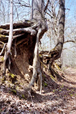
A very
old road-bed that dates from early 1800's and
was reportedly on route on the infamous Trail of Tears (1838).
You
can see how deeply incised it is in the deep loess
(perhaps 10'
here) on the steep slopes and the trees that have been
undermined by
the erosion.
Roger Brown
|
| Re:
Back to Lee |
Lee
Frelich |
| Aug
21, 2006 15:33 PDT |
Bob:
I think Garrison Keillor gets it right--for people who lived in
small towns
30 years ago. There really were people like those he talks
about, they were
in the town I grew up in as well.
These days most Minnesotan's are big city people, or, if they
live in a
small town, like big city people. They are more like Chicagoan's
than
characters in Keillor's show.
I think there is still a much greater awareness and appreciation
of trees
than you might find elsewhere, but that's because trees are
useful for
blocking the wind during winter and providing shade during
summer heat
waves, and they are so likely to blow down here that people
always realize
that a given tree could disappear at any time.
Lee
|
| RE:
Day #4-part 2 |
John
Knuerr |
| Aug
22, 2006 16:57 PDT |
Thought I'd chime in the Loess Hills. If the origin is German
then it's a
variation on "los" (pronounce like Lowe's) which is
paired with "to be": los
sein - meaning: to be loose.
It also has an adjective form: lösbar (pronounce something like
lays-bar)
meaning soluble.
Los sein could easily have become " Low'es sign" and
eventually abbreviated
to "Lowe's" and eventually to the fuss-rhyming
version.
|
| RE:
Day #4-part 2 |
Matthew
Hannum |
| Aug
22, 2006 17:53 PDT |
Thanks for the continuing tale of your trip out west!
The travel across the Great Plains has been particularly
interesting
since I admit that I always thought of that vast region as a
place where
buffalo and seas of grass used to live and where tornadoes and
corn live
now, and that's about it. Since I've never really spent any time
out
there, I had no true understanding of the ecosystem that exists
in the
Great Plains. Thanks for the educational and entertaining posts
about
all of this.
Not sure if I could live without my trees, though... and the
tornadoes
would freak me out if I lived out there, but it must be nice to
have
clear skies all the way to the horizon!
|
|