Bob,
Have you ever visited Medicine Wheel National Historic Landmark
in the
Bighorn Mountains of north central Wyoming? I visited there last
summer. A essay on my trip is found below.
The website for the
Landmark http://wyoshpo.state.wy.us/medwheel.htm
reads:
”The
Medicine Wheel is located in the Bighorn National Forest on the
western peak of Medicine Mountain at an elevation of 9642 feet
in the
Bighorn Range east of Lovell, Wyoming. The 75-foot diameter
Medicine
Wheel is a roughly circular alignment of rocks and associated
cairns
enclosing 28 radial rows of rock extending out from a central
cairn.
This feature is part of a much larger complex of interrelated
archeological sites and traditional use areas that express 7000
years of
Native American adaptation to and use of the alpine landscape
that
surrounds Medicine Mountain. Numerous contemporary American
Indian
traditional use areas and features, including ceremonial staging
areas,
medicinal and ceremonial plant gathering areas, sweat lodge
sites,
altars, offering locales and fasting (vision quest) enclosures,
can be
found nearby. Ethnohistoric, ethnographic, and archeological
evidence
demonstrates that the Medicine Wheel and the surrounding
landscape
constitute one of the most important and well preserved ancient
Native
American sacred site complexes in North America. The Bighorn
Medicine
Wheel is considered the type site for medicine wheels in North
America.
Between 70 and 150 wheels have been identified in South Dakota,
Wyoming,
Montana, Alberta, and Saskatchewan.”
http://crm.cr.nps.gov/archive/22-3/22-03-2.pdf
http://www.sacredland.org/historical_sites_pages/medicine_wheel.html
http://tps.cr.nps.gov/nhl/detail.cfm?ResourceID=841&resourceType=Site
http://www.ldkassociates.com/Friends
of the MW.htm
http://www.ldkassociates.com/MW_Accomplishments.htm
This is a rather dry description of a spiritual site. I
had heard of
the site before in passing and I had seen it’s location on a
map before.
What spiked my interest in the site was an article a few years
back in
Outside Magazine. In the article a white man, who grew up on
several
native American reservation, his father ran a trading post, set
out to
visit a number of sites in the United States considered sacred
or
spiritual sites by various native American groups. One of the
sites
visited was Devil’s Tower and nearby was Medicine Wheel
National
Monument. For many years the site was simply a spot on a
mountain top.
I had no formal protection or oversight. Sightseers could visit,
and
few would take a piece of the wheel home for a souvenir. On his
visit
the author of the article was very moved by the experience he
felt when
visiting the Wheel. It was definitely someplace I wanted to see
for
myself. The site was designated a
National Historic Landmark in 1970.
From that time until the late 80’s there was little done to
safeguard
the site. The Forest Service proposed a development plan in
1988.
During the next few years efforts of the Forest Service, various
groups
and consulting parties, developed a plan to protect the
archaeological
integrity of the site, to educate and inform visitors of the
cultural
significance of the site, and to respect the sacredness of the
site.
This process was in part cooperation, in part antagonistic, and
occasionally acrimonious. Today organization like the Friends of
Medicine Wheel raise money to help provide funding for the
maintenance
of the facilities and preservation of the site in conjunction
with the
USDA Forest Service.
I visited the site last August. I left early in the morning from
Devil’s Tower as the morning sunlight gave an orange glow to
the giant
rock pillar. From there I headed west on Route 14, tuning onto
Route
14A. This takes you into one of the most scenic sections of the
Bighorn
National Forest. On the way I stopped at the Forest Service
visitors
center at Burgess Junction . it is worth a short stop. They have
displays, programs, and information about the area. From here I
headed
off to Medicine Wheel. The Landmark is located along a gravel
road to
the right (north) a couple miles off 14A. The road leads to a
parking
lot, and a ranger hut. From here it is a 1.5 mile walk to the
Medicine
Wheel itself. It is an easy uphill walk along a gravel and stone
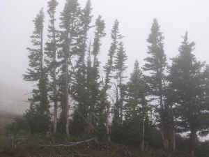
road.
At this point you are above the tree line with scattered
individual
trees (spruce/fir/pine?) standing on the slopes. As I walked up
to the
Wheel the fog began to close in. It was not a threatening
closure, but
more like a comfortable embrace. My view was limited to the
short
distance visible within the fog bank. I could focus on the
details
around me without the intrusion of things in the distance. The
sun was
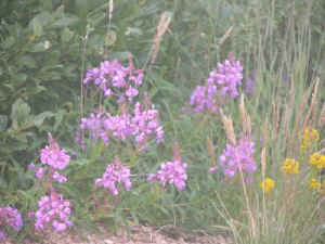
still shinning through the fog. Yellow and violet flowers almost
glowed
fluorescent in the sunlight. Their forms were smeared by the
fog, like
globs of paint in a Van Gogh painting. Small gnarled trees would
reach
into my vision as I headed up the road. White boulders from the
limestone hilltop, an perhaps road construction, had tumbled
down the
slope among the conifers.
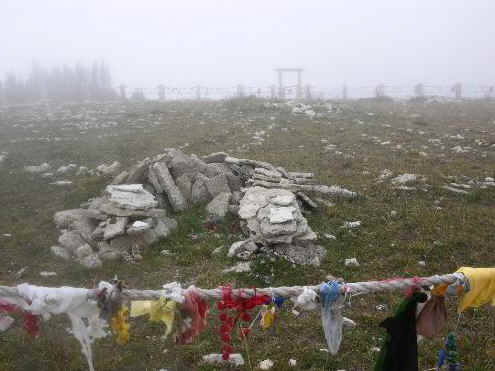
As I approached the Medicine Wheel the fog seemed somehow
appropriate.
I was visiting a sacred, spiritual, site. Fog was needed to
complete
the scene. The Wheel itself was at first indistinct sitting on a
broad
flat atop the mountain. The circle was itself encircled by thick
wooden
posts stuck upright into the ground. These were linked by ropes
marking
the boundaries of the Wheel. When I
arrived at the entrance path a
Native American guide instructed me not to enter beyond the
ropes and to
be sure to only circle the path around the perimeter of the
Wheel in a
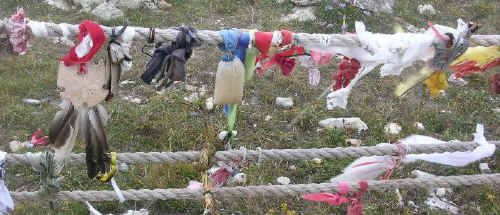
clockwise direction. Even fro a distance I could see the ropes
and
stones were adorned by feathers, colorful bits of cloth, and
other
assorted items left as prayer tokens at the Wheel. The Wheel
itself was
a series of stones lined as spokes radiating from a central
point. On
the far ends of some of the spokes were smaller circular rings
or
horseshoe shaped rock arrangements. All were adorned by colorful
prayer
tokens left by visitors. I took a series of photos. The far
edges of
the wheel were almost lost in the fog. Other visitors were
indistinct
shapes moving on the far side of the circle. As I left the
weather
began to turn colder. It was mid August and there was a chill of
snow
coming in the air.
As I walked back to the car, I thought about what I had seen,
Nodded to
other visitors making their way upward to the Wheel. In the
limestone
bedrock below the road were a series of solution enlarged joints
and
sinkholes. These were classic signs of alpine karst. I wondered
if
there were caves in the immediate area of the Wheel, and
wondered what
they might hold. The ranger back at the parking lot was of
course less
than helpful. She did indicate that there were caves in the
Bighorns,
but was evasive about the immediate area. Oh Well. As I left the
Medicine Wheel and headed to the west the weather cleared. There
is
some spectacular scenery in the mountains. At one point was a
beautiful
view of a couple of isolated trees on the hillside. Far down
below were
open plains forming a backdrop. The wind was howling here. I
could
barely stand firm against the gusts, and holding my camera still
for
photos was impossible. I resorted to driving back and forth
along the
look-out and shooting photos from inside my Tracker with the
window
rolled down. The road eventually wound down to the plains below
and to
the west. There were many photographs taken.
Ed Frank
|