|
Perspective on Mohawk Trail State Forest This following is a series of excerpts reformatted from a longer report on Mohawk Trail State Forest submitted in 2003 by Bob Leverett and others to the Massachusetts Department of Natural Resources. This was the first of a series of annual reports documenting the old growth forest and tree research being conducted at the park by the Friends of Mohawk Trail State Forest. This document focuses on the Native American connection to the state park and the surrounding areas. The full report is available for download on the ENTS website. MTSF Oct 2003 2.83 MB
Friends of Mohawk Trail State Forest We hope that the report series, sanctioned by DCR, will be viewed as Friends of Mohawk Trail State Forest’s contribution to the people of the Commonwealth of Massachusetts, detailing what we have found of significance on our public properties that deserves recognition and in some cases added protection. Certainly protection presently exists for many of the resources, but in other cases, the resources could become at risk for no malice of forethought, but simply because they are not sufficiently understood and officially recognized. With this introduction, we will now turn our attention to the details of Mohawk Trail State Forest. I. Mohawk’s
Obscure Role Curiously, Mohawk is a state forest in search of official appreciation for its scenic, ecological, historical, forest aesthetic, and cultural treasures and its overall scientific value. Here is what the DCR description says about Mohawk Trail State Forest on the DCR website. “Mohawk Trail has over 18 miles of rivers and streams for excellent trout fishing, a swimming area, and a day use picnic area. Many of the original Indian trails, including the Mohawk Trail, are open for hiking. This is one of the most scenic woodland areas of Massachusetts. About 6,000 acres of mountain ridges, deep gorges and many pines over 100 feet tall are home to forest shrubs and flowers, deer and birds.” While this is a “nice-sounding” description, it is understated for the resources that exist at Mohawk. One absence is especially conspicuous. Mohawk is one of the current-day old growth forest icons of the Bay State and actually has been so for decades, courtesy of the Cold River Natural Historical Landmark and more recently because of two special studies, one sanctioned by the Natural Heritage Program and completed in 1993, and the other sanctioned by DCR and ongoing. As a consequence of the work done to date, Mohawk boasts the second largest reserve of old growth forest among the State’s many properties. But equally important to the old growth, Mohawk Trail State Forest is the location of the historic Mohawk Indian trail, its colonial aftermath, and the Shunpike Pike route that was built to avoid a colonial toll road over Hoosac Mountain. Historical markers along State Route #2 discuss the Shunpike, but its exact whereabouts is unknown to all but a few. With such rich natural and historical features, one has high expectations for State recognition and attendant funding and maintenance of appropriate facilities. However, for the quality of its natural features, Mohawk has minimal recreational facilities and interpretive services available to the public. Were it not for its recreational facilities, Mohawk might pass almost unnoticed in the descriptions of State properties. As a consequence, of the very limited descriptive material, the general public knows little about Mohawk Trail State Forest. For that matter, neither do most of the employees of state agencies. This was a problem in need of a solution. The formation of Friends of Mohawk Trail State Forest was in part motivated by the lack of State attention and in several summer seasons, Friends contributed by presenting from 12 to 22 interpretive programs per summer. Before passing, we should note, that the less than satisfactory condition of Mohawk’s infrastructure is due to severe budgetary limitations that are beyond DCR’s control. Despite the dearth of the high quality, or at least well-developed, recreational opportunities that the public has a right to expect in a quality forest or park, over the years, Mohawk has attracted a small, dedicated group of supporters that includes state employees, scientists and naturalists, and ordinary citizens. Some of the ordinary citizens come annually to Mohawk from surprising distances when they could as easily travel to far better known scenic resources. These supporters all seem to recognize that Mohawk’s importance does not lie in organized activities and definitely not in high impact recreation. Devotees are content to walk Mohawk’s limited trail network and to sit quietly at the scenic overlooks atop Todd and Clark Mountains and at the end of the Totem Trail -most notably Indian Lookout at the summit of Todd, savoring a view that author Bill McKibben once described to Robert Leverett as “one of the most understated in New England”. But if Mohawk’s scenery has been understated, it is not overstating the case for Mohawk Trail State Forest to reiterate that Mohawk’s value as a scenic, ecological, historical, forest aesthetic, and cultural resource has not been well understood by either the higher-level State officials or by local residents. There are different reasons for this obscured vision of both state officials and local residents. However, to its credit, the Bureau has also recognized that Mohawk possesses recreational, cultural, and ecological values that transcend its potential role as a timber reserve. The Bureau has recognized that Mohawk’s value to the public goes considerably beyond the convenience of its campground. So despite Mohawk’s designation as a State forest, the Bureau has accepted that Mohawk serves more of the purpose of a traditional state park, as most people think of that designation, and the Bureau has treated Mohawk accordingly. As a consequence of the careful Bureau’s policy toward Mohawk, this modest-sized state forest has retained ecological and historical treasures and the people are indebted to the Bureau’s forbearance. But before we turn to Mohawk’s treasures, let’s first examine Mohawk’s park facilities. Taking inventory of Mohawk’s traditional recreational opportunities, there is a combination picnic area and swimming pool on State Route #2 less than a mile west of the entrance. In addition to picnicking, there is camping. Mohawk’s campground has regular campsites and 6 cabins open year around. For campers and day visitors, there are 7 scenic hiking trails in Mohawk and two tranquil meadows. There is the scenic Deerfield River and its equally scenic tributary, the Cold River.
II. Hiking Trails Of the 7 hiking trails, one in particular has special significance, historically and culturally. We speak of the original Mohawk Indian Trail (actually two trails) and its later colonial aftermath that runs through Mohawk Trail State Forest. The Mohawk Indian trail is also the oldest of the 7 trails and will be described first. Trail #1: The original Mohawk Indian Trail runs through Mohawk Trail State Forest following an east-west path, entering Mohawk near the confluence of the Cold and Deerfield Rivers. In the lower elevations, the original path is obscure, but generally follows the maintenance and campground roads. The route becomes an official trail on the south side of the Todd-Clark ridge as it climbs to the saddle between the summits of Todd to the east and Clark to the west. There the trail turns westward. Unfortunately, the route up the south side of Todd Mountain is badly eroded and multiple branches of the original Indian trail have developed. The original route long ago washed out. However, once the saddle between Todd and Clark Mountains is reached, there is no question as to where the trail is. Post cards from the 1920s show the saddle and a historic hemlock that marked the point at which the Trail reaches the saddle. Some accounts identify the tree as a white pine. The narrow ridge crest leaves no doubt about the trail’s historic route. The old trail runs along the narrow ridge crest from the summit of Todd past the summit of Clark. From the saddle, a spur trail goes eastward to Indian Lookout, which offers spectacular views of Cold River Gorge to the west and the Deerfield Valley to the east. Native Americans supposedly used the spur trail to Indian Lookout for reconnoitering. The west fork of the trail is the mountain branch of the original Mohawk Indian Trail, which became a later and more developed colonial pathway. The western spur follows the Todd-Clark ridge crest. It just bypasses Clark Mountain’s 1,923-foot summit staying to the north side and eventually connecting with South County Road. The area along the Todd-Clark ridge crest remains a trail and always has been. This 1.2-mile stretch is probably the oldest surviving foot trail in Massachusetts, if not in New England. The forest along the trail is largely old growth oak and hemlock. Tree ages are 170 to 300 years, with a small population of hemlocks around 400 years old. The ascent up Todd-Clark and the path along the ridge crest is 1.6 miles in length as a map distance. Trail #2: On the south side of State Route #2 there is a modern hiking path named the Totem Trail. It starts at the swimming pool area on Route #2 and winds through maturing second-growth hardwood forests up to the top of an unnamed ridge that overlooks Trout Brook Cove and Hawks Mountain, which is the large ridge directly to the east. The Totem Trail cuts through an area that was logged in the 1930s, but has recovered into a handsome second-growth forest. The trial terminates within an area of old growth that is described in this report. Map distance is 0.9 miles. Trail #3: From the group campsite, the third scenic trail is short and ascends little Thumper Mountain to provide limited views into Trout Brook Cove and of the Hawks Mountain ridgeline. A fire tower once stood on Thumper Mountain, built by the Civilian Conservation Corp. There is ample evidence of fire in the vicinity of the summit to suggest that the there was at one time a need for the tower. Map distance is 0.25 miles. Trail #4: A nature trail starts from the old colonial Mohawk Trail going from the Group Campsite down to the lower meadow. Going down hill, the trail exits to the left and goes to the upper meadow, crosses most of it, then heads down to the lower meadow, passes a pond, doubles back, and joins the old colonial Mohawk Trail near the John Wheeler Grave site, and back uphill. Map distance is 1.6 miles. Trail #5: At the north end of the lower meadow, what was an old county road bends around Todd Mountain, following the Deerfield River and goes to Zoar Gap. This road has been used in the past as a logging road. It goes through a 1930s Pine Plantation. There are two short spur trails off this trail. One goes to a forest maze and the other goes through more of the pine plantation. Map distance of the trail is 1.7 miles. Trail #6: A trail dedicated in 1997, named the Mahican-Mohawk Recreational Trail, enters Mohawk Trail State Forest at the confluence of the Deerfield and Cold Rivers, following what was probably the original Indian path. The recreational trail skirts Thumper Mountain on the east and then north, joins the nature trail to the upper of the two big meadows in Mohawk, crosses it completely going north and gradually ascends the Todd-Clark ridge on the north side. Park supervisor Denny Moore and Robert Leverett chose the path of the trail in 1995. More will be said about the trail in sections that follow. The part of the trail included here starts at the north end of Stafford meadow and goes to the saddle separating Todd and Clark ridges. Map distance is approximately 1.2 miles. Trail #7: A hiking/cross country sky trail branches from the maintenance road to the dump over to the original Mohawk Trail that now connects the campground road to the lower meadow. Map distance between the access roads is approximately 0.7 miles. Taking all the spurs including return paths on the campground roads (about 1.3 miles), Mohawk Trail State Forest has slightly over 9 miles of walking trails. An 8th trail, which has been marked by ski mobile enthusiasts in the Trout Brook area of Mohawk, is not included here, nor is the part of the old Shunpike route that ascends Clark Mountain. III.
The Right Role for Mohawk Trail State Forest in the Massachusetts
System of Forests and Parks As of today, many people who visit Mohawk Trail State Forest do so to gain convenient access to the Deerfield River for river canoeing, rafting, kayaking, and fishing. River running has been a steadily growing sport and Mohawk is a convenient place to camp to pursue the sport. A lesser number of visitors come to enjoy Mohawk’s modest network of hiking trails. Still fewer visitors come to see the exemplary stands of trees that are Mohawk’s most distinguishing feature. Recognition of the latter feature has been motivated by a large number of articles written about the trees of Mohawk. However, despite the only modest number of visitors in the last category, Mohawk has also been visited in recent years by a surprising number of dignitaries who have vestigial connections to the trees. The dignitaries have been mostly Native Americans who come to honor and rekindle a faded cultural past. The Native dignitaries have come to see Mohawk as a symbol of wilderness pre-settlement eastern America and visit it to re-establish connections through ceremony and quiet meditation to a forest and cultural heritage that once nourished them. We should point out that visitation and use of Mohawk by Native Americans is completely unconnected to the commercial exploitation of Indian heritage as seen along State Route #2 between Greenfield and Charlemont, Mass. The Indian use of Mohawk is in the best of taste and entirely appropriate to a rebirth of recognition of the regions historical roles and roots. The Natives may lead the way because relatively few of today’s visitors to Mohawk Trail State Forest are aware of the region’s role in the French and Indian War during the 1750s and early 1760s or the Revolutionary War in the 1770s and 1780s. However, the Mohawk Trail served the region as a pathway between the watersheds of the Hudson and Connecticut Rivers. It was a war trail during the above periods and probably a trade route before. However, for years, the route of the original Indian trail and its colonial upgrade was largely lost until a sizable effort was organized in the early and mid-1990s by Lauren Stevens of Williamstown, MA to map the original route that joined the Valleys of the Hudson and Connecticut Rivers. The primary objective of Lauren Stevens’s project was to create a recreational trail that followed the original route of the Mohawk Indian Trail where possible and initially joined the watersheds of the Hoosic and Deerfield Rivers. A larger plan would extend the old Indian trail network, possibly even into Canada. Enough information was assembled from various historical sources to identify the Mohawk Trail route fairly reliably and as a consequence today we have the Mahican-Mohawk Recreational Trail. That it is an outgrowth of Lauren Steven’s efforts stands as a testament to the importance of a single person’s vision. The recreational trail concept and construction was fully supported by Friends of Mohawk Trail State Forest. The culmination of the trail project was the dedication of the Trail through Mohawk in a ceremony held on July 19, 1997 and attended by DCR Commissioner Peter Webber. Friends of Mohawk Trail State Forest was instrumental in securing funding for the project. In fact, it was primarily the connections of Jani Leverett, the Friends president, to U.S. Congressional Representative John Olver that led to the trail’s funding. There is no question that the historical and cultural past of the Mohawk Trail State Forest is inextricably interwoven with the original Mohawk Indian Trail and its colonial upgrades. The original Indian trail was upgraded, starting in 1753 by Elisa Hawley, and ran along the Todd-Clark Ridge and down its southern side. A second road, the Rice Road, was completed sometime after 1764. It climbed the north side of Clark Ridge and later became known as the Shunpike. As an example of the historical importance of these trails, Benedict Arnold used the Shunpike. To a lesser extent, Mohawk is connected to the European settlers of the area who lived on homesteads adjacent to the Cold and Deerfield Rivers after the Revolutionary War. War veterans were often paid in land. However, little in the way of specific information is known about their lives other than that they were sheep farmers. The John Wheeler homestead at the east end of Mohawk is the only one that has any documentation associated with it and that is mainly because of the Wheeler gravesite and Wheelers role as the ancestral family to five American presidents. The two Bush presidencies are among the five. If there is little known about the European settlers of Mohawk, there is even less known about the earlier Indian visitors other than a few forays across the Mohawk Trail by the Mohawk in 1663 and 1674. While an old Indian Encampment site at the confluence of the Cold and Deerfield Rivers has been known about throughout the history of the region, it has not figured into the cultural or natural history of the interpretive programming within Mohawk. Most of the site’s artifacts were pilfered long ago and today the old encampment is a dumpsite for the Headquarters. This ignominious end to the seasonal encampment symbolizes the degree to which the role of Native peoples in the area is still little appreciated and less understood. It is the hope and intention of Friends of Mohawk Trail State Forest to one day have a major archeological excavation of the site conducted by reputable archeologists. If Mohawk Trail State Forest is to serve its highest purpose, more people must discover Mohawk’s historical and cultural roots and the State must ensure that those roots receive complete protection. Of course, any remaining archaeological or historical sites will receive protection, but identifying potential sites presents special challenges. Remaining artifacts are buried. The discoverer of the occasional artifact usually carries it off. However, from a strictly cultural perspective as opposed to a historically correct one, connections of Mohawk’s combination of Indian and colonial past have come alive. They have been revived through current-day associations between Mohawk Trail State Forest, Friends of Mohawk Trail State Forest, and the Indian nations that visit Mohawk and perform private ceremony there. What are the nations? The Mohawk, Canadian Algonquin, Lakota, Cherokee, Nipmuc, Wampanoag, and Narragansett have been most prominent. A Mohican dignitary has visited on one occasion and taken part in the dedication of the Mahican-Mohawk Recreational Trail. Today, the association mentioned above between Indian Nations, Mohawk Trail State Forest, and Friends is maintained by symbolic dedications of forested areas and individual trees within several dominant and accessible white pine stands. The purpose of the dedications is to honor both Native nations and individual Native personalities. These dedications have been the principal means used by Friends with the permission of the Headquarters to cement connection to Native culture in a way that can enrich the entire region for years to come. Will the connections create an economic bonanza? We certainly hope not. The importance of extending this role of Mohawk Trail State Forest is not about promoting gaudy, mindless tourism, or attracting hoards of visitors, though modest economic benefits could accompany the right kind of expansion of the role of Mohawk. Aside from the cultural connections that utilize some of Mohawk’s pine stands as symbols, Mohawk Trail State Forest has another equally worthy purpose to serve and it is one that can easily be fulfilled. In fact, it is being fulfilled with no ecological penalties. IV. Mohawk’s
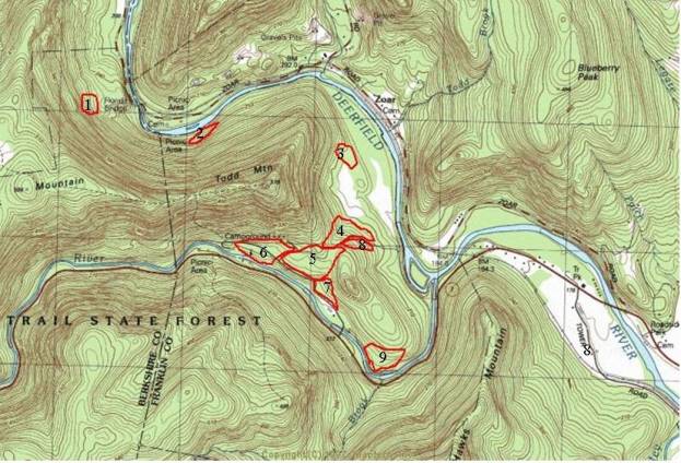
Present Composition Mohawk Trail State Forest covers slightly less than 6,800 acres of land, with the latest acquisition of approximately 300 acres. Within Mohawk’s boundaries, several areas of old growth and exemplary second-growth forest can be found. There are areas of very young forest also. The boundaries of all are imprecise and in future work we will attempt to refine them. We will be looking at Mohawk through different lenses, not just an old growth lens. The mature second growth and the youngest forests will receive equal attention. Questions we pose to ourselves are: (1) how do the three differ, (2) what is the direction of succession in each, (3) what kinds of disturbances might we expect in the future and can we predict their impacts. To provide readers with the best possible picture of Mohawk’s present forests, we have divided Mohawk up into regions that follow our old growth research and confirmations. This delineation by old growth concentration will become more apparent in the paragraphs that follow. V. Important
Forest Sites For the purpose of presenting areas of old growth, exemplary second growth, historical and cultural features, and forests of high aesthetic value, we have divided Mohawk Trail State Forest into nine regions. The total area of these regions is 3,178 acres, which is slightly less than half of Mohawk Trail State Forest. A topographical map has been provided for each of the areas. The regions we have defined are listed below: 1. Thumper Mountain-Headquarters Forest: 182 acres 2. Todd-Clark Ridge East-side Forest: 211 acres 3. Todd-Clark Ridge North-side Forest: 384 acres 4. Trout Brook Forest: 597 acres 5. Cold River North-side Forest: 820 acres 6. Black Brook Forest: 128 acres 7. Todd-Clark Ridge South-side Forest: 530 acres 8. Cold River Natural Landmark Forest: 280 acres 9. Manning Brook Forest: 46 acres These boundaries do not follow ecological divisions. The boundaries are largely for our convenience. The Thumper Mountain-Headquarters Hill region is an area that has been heavily used by humans. Outside of a marginal area of old growth on Thumper Mountain, this region is characterized by 60 to 120-year old forests. By contrast the Todd-Clark South-side Forest is a region that has been impacted far less by direct human activity, but has been heavily affected by past fire. This has created an oak forest that varies in age from between 120 to 180 years with scatterings of older trees growing on slopes that often exceed a grade of 70%. The regions are then fairly differentiated by topography and forest type. 1. Thumper Mountain-Headquarters-Forest The headquarters area of Mohawk Trail State Forest sits at an elevation of 700 feet above sea level at the base of Thumper Mountain, which is an extension of the Todd-Clark mountain ridge. The crest of Todd-Clark runs in an east-west direction. Thumper is an extension of Todd and runs in a northwest-southeast direction, ending at the confluence of the Deerfield and Cold Rivers. Thumper’s summit is 1043 feet above sea level. It rises 354 feet above the Cold River at Mohawk’s headquarters, which is on the south side of Thumper’s summit. Thumper rises 453 feet above the Deerfield River to the east. The steepest part of the grade up Thumper over a distance of 300 feet is between 55 and 60 percent. A short rise just beneath the summit has an 88% grade for a map distance of 120 feet. The east end of Thumper drops gradually to the confluence of the Cold and Deerfield Rivers. Large river terraces surround Thumper’s high ground. These terraces were the areas that European settlers occupied in the late 1700s and used for sheep pasturing. A later use was as a dairy farm. The Headquarters itself sits on an old outwash terrace of the Cold River. Following the paved campground road around toward the cabins, one reaches the first of two leaching fields. The paved road passes the leech field and bears to the left. A dirt road branches to the right heading toward Mohawk’s group campsite. The pines in this area on both sides of the paved and dirt roads have been named the Pocumtuck grove or the Pocumtuck Pines. The Pocumtuck Pines area continues along the dirt road to the group campsite. Beyond the group campsite, to the east, on the south side of the dirt road (the colonial Mohawk Trail), the pines are called the Cherokee grove. The Cherokee pines are older than those in the Pocumtuck grove by probably 30 to 40 years, if not 50 to 60. Most of the Pocumtuck grove is populated with pines that are 75 to 110 years of age. Because the stand is still relatively young, it hasn’t self-thinned and in places basal areas are over 300 square feet per acre. The two leaching fields provide convenient places to observe the Pocumtuck Pines. Visitors are afforded the opportunity to observe the impact of the opening up of a white pine stand. Trees along the boundary of the leaching fields receive extra light, which is good for growth, but the trees are also subject to extra wind damage. Courtesy of DCR, the Pocumtuck Pines area is one of Friends’ main research areas into the growth patterns white of pines that are in the 75 – 110-year age bracket. We are especially interested in monitoring the health of the pines on the boundaries of the leech fields. Even though the Pocumtuck Pines are fairly young, they have already reached remarkable heights. At least 15 pines are now over 140 feet in height and six are over 150. The 150-footers include the Metacomet, Massosoit, and Frank James trees – all Wampanoags and 3 unnamed trees confirmed on October 26th, 2003 by Will Blozan. Of the six 150-footers, the Metacomet tree is both the overall largest at 151.3 feet in height and 9.0 feet in circumference. However, besides the six 150-footers, another two pines top 148 feet in height. In 2 to 3 years, they will join the other 150-footers and the stand will have at least eight 150-footers visible from the campground road. Visitors can walk the campground road and gaze upward into the crowns of 150-foot pines growing in the Pocumtuck, Trees of Peace, and Mast pine groves - without ever having to leave the convenience or safety of the road. More will be said about the 150 Club in subsequent paragraphs. Another area of impressive pines is the Encampment Pines, which are located on the peninsula that separates the Cold and Deerfield Rivers. Four white pines along the cross-country ski trail exceed 140 feet and one reaches to 151.7 and 10.0 feet in circumference. Hardwoods in the area commonly exceed 100 feet. A Norway spruce reaches to 117.7 feet and is the tallest of its species measured in Mohawk. Other species in the Thumper Mountain-Headquarters area are not particularly conspicuous although they do well by the tale of the tape. The hardwood canopy is typically 90 to 105 feet. The larger oaks measure 28 to 35 inches in diameter. A walk down the road from the entrance to a dumpsite is quite pleasant and there is a cluster of 10-foot circumference white pines near the first dumping area. 1a.
Fire Tower Site A fire tower erected by the Civilian Conservation Corp once stood on the summit of Thumper Mountain. It has been removed. The summit may have once served as an observation area for Native Americans. So far no artifacts have been found. 1b.
Old Indian Encampment Site A second historic feature of Thumper Mountain is an area at the confluence of the Deerfield and Cold Rivers that served as an old seasonal Indian encampment. The encampment shows up on old maps of Mohawk. Several citizens of Charlemont remember artifacts from the encampment site. We assume the site was used as a location for either trading or fishing. The latter purpose is the more likely early on, since the Cold River was an important spawning ground for the Atlantic salmon in both the pre and post-settlement eras. Salmon Falls at Shelburne Falls, MA was a prime fishing ground for both indigenous peoples and later white settlers when the populations of Atlantic salmon were still high. Items found at the encampment suggest trade was important, but later. The site was well known in years past, but has been pilfered and sadly treated with indifference by the State. In fact the area is a dumpsite for Mohawk Trail State Forest. Why this is the case is unclear, but it is not the fault of local management. The State Forest has no funds for cleaning up the area. This should be established as a future project and adequately funded by DCR. 1c.
Tree Planting Ceremony In April 1996, Chief Jake Swamp planted a white pine as part of his ceremony and recounting of the formation of the Iroquois Confederation. The legendary Hiawatha figure stems from the Iroquois’s mythology. However, the Hiawatha of the Iroquois mythology is not the same as in Longfellow’s poem. Chief Swamp’s ceremony took place in front of the Nature Center. We note that Chief Jake Swamp is the officially recognized “Peace Tree Chief” of the Mohawk Nation, Akwesasne Reserve. Chief Swamp has gone around the world planting trees in his support of world peace. He has honored Mohawk Trail State Forest with two planting ceremonies., one in May 1994 and one in April 1996. 1d.
Mohawk-Narragansett Meeting On July 19, 1997, John Brown, then a representative of the Narragansett Nation of Rhode Island and Grand Chief Joseph Takwiro Norton of the Kanawake Mohawks of Canada came together at the pavilion at Mohawk Trail State Forest Headquarters and revived the friendship pact that had once bound their two nations. This was a historic event deserving of documentation and official high-level State recognition. But despite the relatively little attention given to it, the fact remains that the event took place in Mohawk Trail State Forest and we all are the richer for it. We hope to have a future event at Mohawk that commemorates the occasion.
1e. Dedication
of Mahican-Mohawk Recreational Trail On July 19,1997, the Mohawk Trail State Forest portion of the Mahican-Mohawk Recreational Trail was dedicated by then DEM commissioner Peter Webber. The event marked an important step in the recognition of the region’s historical roots. 2. East-side Forest (East Side of Todd Mountain and Meadows): The East-side Forest is so named because of the prominent area of old growth that stands out in the bowl of Todd Mountain from considerable distances. The old growth can be seen very clearly from River Road across the Deerfield River. The East-side forest is bounded by the northeast and southeast backbones of Todd Mountain. The backbones form the western boundaries of the East-side Forest. On the north, the boundary goes from the summit of Todd down to the Deerfield River. On the south side, the boundary runs from the summit down to the old Mohawk Trail road and then follows the road down to the lower meadow and then down to the river. The upper and lower meadows are included in the area designated as the East-side Forest. 2a.
Tall Pines of the East-side Forest The most striking woodlands of the east-side forest area are two mature stands of white pine. One is at the north end of the upper meadow (known locally as Stafford Meadow) and the other stand is at the south end. The north end stand has been named the Algonquin Pines in honor of the Algonquin-speaking Indians who lived in the surrounding regions. The Algonquins were New England’s Indians. The Mohawk, which were part of the Iroquois Confederacy, were New York Indians. The south end stand is called the Trees of peace to honor all Indian nations, but especially those that we assume used the Mohawk Trail. From our research, this at least includes the Mohawks, Mahicans, Pocumtucks, Nipmucks, Abenakes, Wampanoags, and Narragansetts. Other Iroquois nations likely used the trail on occasion and perhaps the Agawams and Sokokis. However, this is speculation on our part. Both white pine stands are composed of trees that are in the 125 to 150-year age class. However, at the lower borders of the stands there are belts of younger trees. Basal areas of the Algonquin Pines are impressive. They vary from 220 to 320 square feet per acre. Basal areas for the Trees of Peace are typically 200 to 280 square feet per acre. The acreage of the Algonquin pines is 4 acres. The acreage of the Trees of Peace within the east-side forest, including an area called the Mast Pines, is approximately 17 acres. The total area of the Algonquin Pines and the Trees of Peace then is approximately 21 acres. This does not include the areas of younger pines at the borders such as those closer to the Deerfield River. The area of younger pines covers around 40 additional acres. The most noteworthy physical feature of the 21 acres of mature pines is unquestionably the remarkable heights that the trees have reached. There are 25 white pines in the Algonquin Pines, Trees of Peace, and Mast Pines that reach 150 feet in height, 11 are in the Trees of Peace, 10 are in the Algonquin Pines, and 4 are in the Mast Pines. These pines added to 1 in the Cherokee Pines, 7 on the north side of the Todd-Clark ridge, 6 in the Pocumtuck Pines, and 1 in the Encampment Pines equals 40 and gives Mohawk the third highest concentration of 150-foot white pines in the entire Northeast. There may be a few places in New York’s vast Adirondack Park that have similar concentrations, but so far we have confirmed on a handful of 150-footers in the Adirondacks. The greatest concentration of 150-footers in Mohawk includes the 11 pines in the Trees of Peace, the 4 pines in the adjacent Mast Pine area just down hill, and 1 pine in the adjacent Cherokee Grove uphill for a total of 16 pines over 150 feet tall in a concentrated area. At least 3 and probably 4 pines will join the 150 Club with the next 3 to 5 years, barring blow down. The tall tree significance of the area, at least from a statistical perspective, will likely be maintained for quite a number of years. Those are the general statistics. What about specific trees? The two most notable pines in the combined Trees of Peace, Mast Pines, and Algonquin groves are the twin sentinels, the chiefs. The Chief Jake Swamp Tree and the Chief Joe Norton Tree, both named for current-day Mohawk chiefs, are two of Mohawk’s five flagship pines. Both of these pines were initially measured by transit in November of 1992 by Jack Sobon and Robert Leverett. At that time the Jake Swamp tree was 155.2 feet in height and the Joe Norton tree was 155.6 feet. Today the trees are 163.5 and 162.2 feet in height, respectively, and remarkably both heights include recovery from small crown breakages. The Joe Norton tree suffered the more extensive breakage. Not counting recovery, the average annual height growth for the Jake tree has been 9.1 inches. Given that the age of the Jake Swamp white pine is approximately 145 years, this is a higher than expected annual growth rate for white pines in that age class – at least as indicated from the available silvicultural data. The expected rate of height growth for trees approaching 150 years of age is more on the order of 3 to 5 inches per year. At least, that is our understanding. It is important to understand that the Jake Swamp tree has been climbed twice (1998, 2001) and the Joe Norton tree once (2001) to get precise height measurements with plumb lines. So the current measurements we cite are accurate to within one to three inches. Incidentally, we know of no such comparable tree height data on tall eastern trees that are standing.
2b. Location
of Named Pine Stands.
Key to white pine locations:
1. Shunpike Pines
2. Elders Grove
3. Algonquin Pines
4. Trees of Peace
5. Pocumtuck Pines
6. Indian Springs Pines
7. Headquarters Hill Pines
8. Cherokee Pines
9. Encampment Pines
2c.
Tree of Peace in Lower Meadow In May 1994, Chief Jake Swamp of the Akwesasne reserve at Hogansburg, NY, planted a white pine near the north end of the lower meadow at a ceremony entitled “In Remembrance of the Lost Ones”. Chief Swamp recited, in abbreviated form, the legend of how the Iroquois people formed a single nation. Approximately 240 people attended the event. The tree is one of two planted by Chief Jake Swamp as symbols of support for Mohawk Trail State Forest’s role in maintaining cultural awareness of the past role of the Mohawks in western Massachusetts.
2d. Trees of Peace
Dedication A sign stands within a path down through the Trees of Peace dedicating the grove to Native Americans who would have traveled the area. Commissioner Peter Webber of the Department of Conservation and Recreation (DCR) dedicated the Trees of Peace grove in July 1997. DCR was then named Department of Environmental Management (DEM). The dedication was part of an on-going effort to strengthen cultural ties between Native Americans and European Americans by recognizing the frequently misunderstood role of the former in the pre and post-settlement eras of this nation.
2e. Lakota
Ceremony and Tree Dedication at the Trees of Peace In November 2001, Chief (Dr.) Arvol Lookinghorse led a ceremony within the Trees of Peace stand, which was attended by 45 people. Chief Lookinghorse is perhaps one of the 4 or 5 best-known members of the Lakota Nation in the world. He has a United Nations role as a representative of indigenous groups, which seek a formal seat at the United Nations. Chief Lookinghorse is internationally known for his work for world peace. Accordingly a tree in the grove, formerly named the Flag Tree, was renamed for Chief Arvol Lookinghorse. A second pine was named for elder Dave Chief, who regularly accompanies Dr. Lookinghorse on his trips. The dedications mark an area now referred to as the Lakota Grove.
2f. Algonquin
ceremony In the fall of 1993, Canadian
Algonquin elders William Commanda and Frank Decontie performed a
ceremony at the west end of the Algonquin Pines. William Commanda is an
international figure and spiritual leader of the Algonquin nation in
Canada. The ceremony marked the beginning of a 7-year association
between the Algonquins and Mohawk Trail State Forest. Frank Decontie
became a Native American advisor to Friends of Mohawk Trail State
Forest. Trees have been named in honor of William Commanda and Frank
Decontie who passed away in August 2001. A tree has also been dedicated
to Sandra Decontie who carries on her husbands work. Frank Decontie’s
tree was the first in the Algonquin Pines to be confirmed to over 150
feet.
2g. Mike Perlman
Tree Dr. Michael Perlman was a well-known ecologist and psychologist who died in April 1998. He was a peace activist and a tireless supporter of environmental causes. A tree, the Mike Perlman Pine has been named in his honor. The tree grows in the Algonquin grove. Dr. Perlman wrote several books. One is entitled “The Power of Trees – A Reforesting of the Soul”. He was a great friend of Mohawk Trail State Forest.
2h. Karl Davies Tree On October 25, 2003, a ceremony was held for Karl Davies of Northampton, MA to honor Davies for his exemplary record as a forester and caring custodian of the forests. Sixty people attended the symbolic dedication of the tree. Karl Davies was known for his attention to the needs of wild life and the importance of maintaining the genetic heritage of native tree species. He was a fierce critic of poor forestry practices and was working on a process to evaluate a cutting operation in terms of the best silvicultural practices for the long term ecological and economic health of the forest.
2i. Music
and Poetry About Mohawk Trail State Forest There have been at least 3 songs and 3 poems written about Mohawk Trail State Forest in the 1990s, inspired by the tall trees and the meadows of the East-side forest. Collecting the music and poetry will be an area of future research for Friends.
3. North-side Forest (Todd-Clark Ridge): The North-side Forest of the Todd-Clark ridge is no ordinary place. It has a story to tell. The entire region is a bowl-shaped mountainside that creates a fairly large area of slow drainage. Elevations on the north side of Todd-Clark range from 590 feet at the Deerfield River to 1923 feet atop Clark Ridge. The summit of Todd is 1,711 feet. The drop from Clark to the Deerfield represents a 1,333-foot elevation change and the change occurs in a relatively short distance. The average grade along a transect from the point of rapid drop from Clark’s summit down to the river is 66%. Overall, the slope of Todd-Clark’s north side ranges from 50 to 75%, with the mean around 60%. An important feature of the bowl is its boulder fields, which along with the relatively steep slopes and a very narrow ridge top limited logging operations over the 385 acres of the north side to the bottom half of the ridge. However, fingers of old logging operations extend farther up into areas with few boulders. The lower slopes of Todd-Clark received a good deal of attention from loggers in the 1930s as part of a Civilian Conservation Corp effort. The paths of several skid roads reaching halfway up Todd-Clark are especially apparent in the winter from nearby Negus Mountain.
3a. Mohawk
Indian Mountain Trail An even more historic feature of Mohawk Trail State Forest runs along the summit of the Todd-Clark ridge. This second feature is one of our most historic in all of Massachusetts, yet perplexingly one of our least understood and least appreciated. We speak of the mountain branch of the historic Mohawk Indian Trail that runs along the crest of the Todd-Clark ridge. Another branch follows the Cold River, but its exact path has not been preserved. In fact, all but segments of the river path that exist as county roads have long been obliterated due to erosion and timbering. However, the mountain branch continues to exist as a trail for about 1.5 miles. Its use was first by Indians, then by British soldiers and colonials, and finally, only by colonials. The extent of all the uses is more speculation than fact, but it did serve as a supply route for Fort Massachusetts at North Adams. The origin of the trail probably dates back to the late 1500s when contact between the Mohawk in eastern New York and Algonquin tribes in western Massachusetts and the Connecticut River valley was being established most likely for trade. As the Mohawks gained dominance due to their receipt of weapons from the British, the route developed into a warpath. It is its warpath fame for which the trail is primarily known. Indian nations that made use of the trail include Mohawk, Pocumtuck, Nipmuc, Abenaki, and Wampanoag. King Phillip took from 400 to 600 warriors across the path in 1674 to try to gain the support of the Mohawk for what has become known as King Phillip’s War. The Mohawk used the trail to attack the Sokoki in New Hampshire and the Pocumtucks in what is today Old Deerfield. Famous personages that traveled or probably viewed the trail included Ethan Allen, Benedict Arnold, and the Mohawk ambassador Saheda. It is not clear if Henry David Thoreau ever walked the trail when he was in the Charlemont area. The odds are that he didn’t. Nor we doubt that Mark Twain did when he visited a friend in Charlemont, Mass. We’ll never know for sure. At least a couple of authors have written about the historic Mohawk Trail route atop the Todd-Clark ridge. Research has centered on the rediscovery of the mountain trail by an elderly gentlemen named Deacon Field who along with Judge Williams reconnected to the trail as remembered by Field as a boy. The rediscovery came late in the 1800s. The trail lay dormant for close to a century and apparently only a few people were alive in the latter 1800s who could remember that the trail had ever existed. The last author to write about the trail apparently did so from an armchair perspective. He doubted that Indians had ever made use of the mountain route. He was evidently not aware of a substantial cache of artifacts that had been found along the trail over the years by residents of Charlemont, Mass. Robert Leverett is acquainted with a family whose son had quite a collection. As previously mentioned, the role of the mountain branch of the Mohawk Trail became important around 1760 as a re-supply route for Fort Massachusetts in North Adams. After the end of the French and Indian Wars around 1763 the trail may have been known as Hawk’s Road. However, it was notoriously treacherous descending Todd Mountain from the saddle between Todd and Clark on the south-facing side. What is named the River Road was the Turnpike as it went up river to what became later known as the village of Hoosac Tunnel. Today, the 1.5-mile surviving mountain branch of the Mohawk Trail exists as a recreational path, known for its spectacular views. The scenic vistas across and into the thousand-foot deep Cold River gorge prompted author Bill McKibben to describe the scenes to Robert Leverett in the early 1990s as one of the most under-appreciated areas he had seen. In 1997, Tom Dosteau, a pipe carrier for the Algonquins performed a ceremony at Indian Lookout.
VI.
Listing of All White Pines in Mohawk Trail State Forest,
Massachusetts with Heights of 150 Feet or More, Oct 28, 2003
VII.
Trees Climbed and Taped in Mohawk Trail State Forest
Transit: Height
Measured by Transit Jack Sobon and Robert Leverett Professional arborists have made the above climb. These arborists do not employ spikes or any equipment that could damage the cambium layer of the pines. We emphasize that these climbs are strictly for gathering data. They are not sporting events. Members of the Eastern Native Tree Society, DCR, and special guests will be the only people present on future climbing event. Over the next several seasons, new climbs are planned for the Joseph Brant Pine and the Algonquin Pine, and re-climbs of the above trees.
VIII. Peace Park Concept Over the last several years, a number of small indigenous groups have held quiet events at Mohawk Trail State Forest. While these indigenous groups arguably have made the greatest use of Mohawk Trail State Forest for ceremonial purposes, other groups have found the ambience of Mohawk conducive to prayer and meditation. Over the years Robert Leverett has guided scores of religious groups around the upper and lower meadows of Mohawk. On his visit in November 2001, Chief Arvol Lookinghorse voiced the opinion that Mohawk would be an ideal setting for simple ceremonies that honor world leaders of peace. This has led to the concept of designating a small area of Mohawk as a peace park, an international peace park. While there is no doubt that pros and cons exist for this idea, pursued on a modest level, initially the pros appeared to outweigh the cons. Many people with whom we have spoken like the idea of small accessible areas of Mohawk Trail State Forest being used to honor international leaders of peace in a non-denominational way. The dedication of individual or small areas of white pines in the named areas for the purpose recognizing international figures of peace could be a bold statement of Mohawk. It could also lead to unintended consequences. Recently, Friends intensified its efforts to explore the idea of recognizing international leaders of peace through symbolic dedications of white pines in the accessible area of Mohawk. Viewed from one perspective, the white pines offer us living symbols to use and are especially appealing to earth-conscious movements. Please bear in mind, that use of a small part of Mohawk is just a concept, but a superficially appealing one if pursued on a modest scale for several reasons. One reason stands out in particular. The greatest appeal of the peace park concept is that it represents a non-destructive use of a spectacular resource and could be combined with the non-destructive science objectives to the benefit of many. This is the appeal that propelled us to further investigate the concept. The concept’s principal negative is that it might eventually attract too many people who have little or no interest in the forest, the wildlife, and the history of the area. People without a real connection to the forests of Mohawk who come to honor other people and their accomplishments, while noble in its own right, could eventually change the focus and priorities that we have defined in the paragraphs above. This is certainly not what we have in mind. Our present leaning is away from the concept. We will seek more public input, but after an initial enthusiasm and making a few discreet tests, we have cooled off. The risks appear unacceptable. The risk to the white pines from excessive foot trampling around the base of the trees and the trampling of the herb layer appears too great. The more prudent course is to honor Native American nations and individual Indians of prominence.
|
||||||||||||||||||||||||||||||||||||||||||||||||||||||||||||||||||||||||||||||||||||||||||||||||||||||||||||||||||||||||||||||||||||||||||||||||||||||||||||||||||||||||||||||||||||||||||||||||||||||||||||||||||||||||||||||||||||||||||||||||||||||||||||||||||||||||||||||||||||||||||||||||||||||||||||||||||||||||||||||||||||||||||||