Some random thoughts considering the distribution of species we
found on
the various islands of the Allegheny Islands Wilderness.
Edward Frank, September 19, 2007
Introduction
Islands in rivers are by nature ephemeral. They come and go.
Rivers
are dynamic. This can be seen in rivers like the Mississippi
where
remains of paddlewheel boats are found in fields miles from the
present
river course. In rivers like the Allegheny the situation is
somewhat
different. It isn’t just that the river is much smaller in
scale, but
it is incised into the landscape and not free to wander about a
broad
floodplain. Thompson Island is known from historical accounts
dating
from the Revolutionary War. The age of these islands can be seen
reflected in the age of the trees found growing on them Some of
the
bark and physical characteristics of individual specimens speak
of great
individual age. The ancient slippery elm and red oak on Thompson
Island
and Butternut on Baker jump out in that regard. The sycamore and
silver
maple have reached immense size. The hawthorns normally are
regarded a
small shrub while here they reach tree size comparable in size
to those
found anywhere in the nation. Who knows how old they may be?
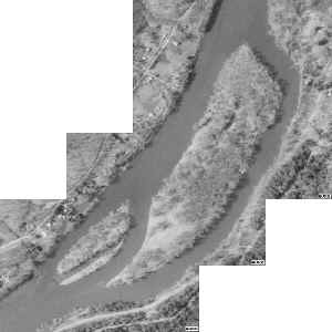
Air Photo of R. Thompson Island
The islands do show signs of the dynamic nature of their
environment.
Along the shores bank erosion can be seen. Sand bars are
building in
the river channels. In the islands themselves are the remnants
of water
channels that still flow during high water cutting the larger
island
mass into smaller segments. In drier times these channels
contain
inlets and isolated oxbow lakes and swamps. I am sure that some
of the
smaller island fragments occasionally rejoin and separate from
the
larger islands during the larger course of time as separating
channels
infill and are opened again. The longer term effects of the
Kinzua
Reservoir on the stability of the islands in the wilderness is
unknown.
If we assume the islands in the Allegheny Islands National
Wilderness
are all old and similar in age then we can expect certain
patterns in
the species diversity found on the islands: 1) Larger islands
would be
expected to have more species diversity than smaller islands; 2)
Islands
with greater elevations would be expected to have a higher
diversity; 3)
Islands with signs of greater stability would be expected to
have a
greater diversity. The second factor that will dramatically
affect the
diversity noted is the thoroughness with which the islands are
examined
for different species. Those islands that were only visited for
short
scout trips or for just measuring tall trees will likely reflect
a lower
diversity than those examined in more detail. This artifact does
not
reflect true diversity, just that observed by visitors.
Location
http://www.fish.state.pa.us/watertrails/alleg/trailmap.htm
Major islands included in the wilderness include:
http://www.fs.fed.us/r9/forests/allegheny/recreation/wilderness/allegheny_islands/
Seven islands in the Allegheny River, totalling 368 acres, are
part of
the Allegheny Islands Wilderness. All are alluvial in origin,
which
means they were formed by water-carried deposits of sand, mud
and clay.
They are characterized by river bottom forest trees such as
willow,
sycamore and silver maple. The islands are located between
Buckaloons
Recreation Area and Tionesta, PA. They are:
· Crull's Island (96 acres) has large old river bottom trees.
· Thompson/s Island (67 acres) The only Revolutionary War
battle in
northwestern Pennsylvania occurred on this island. It has an
exceptionally fine riverine forest.
· R. Thompson's Island (30 acres)
· Courson Island (62 acres) The island may be viewed from the
Tidioute
Overlook.
· King Island (36 acres) has good riverine forest with many
trees 35-50
inches in diameter.
· Baker Island (67 acres) stood in the path of one of the two
tornadoes
which crossed the Forest on May 31, 1985. Most of the trees were
blown
over in the storm.
· No Name Island (10 acres) is about half river-bottom trees
and half
dense undergrowth.
In addition to these islands as part of this initial examination
Stewards Island, owned by U. S. Forest Service and part of
Allegheny
National Forest, and Fuelhart Island. Apparently privately owned
were
included in the survey. We landed on Stewards Island and
measured
several trees. Some trees on Fuelhart Island were noted as we
floated
past in a canoe, but we did not land. located
Background Information
Crull Island was explored by Dale Luthringer in September 7,
2004. He
wrote of his trip (Sept 27, 2004)
http://www.nativetreesociety.org/fieldtrips/penna/allegheny_islands.htm
The report read in part: “Decent sized sycamores jumped into
view
almost immediately. Most ranged from 7-9ft CBH with heights that
maxed
in the upper 120's. I was also delighted to measure my first
naturally
grown silver maples in the state. I continued downriver in the
middle of
the island and soon found
a very nice sycamore (13.4ft CBH x 123.7ft high) and some
respectable
sugar maples. There was a small section of old trees showing old
growth
characters: (staghead branching, balding and deep fissured bark
characters, some large CWD). There was a slippery elm here that
had such
deep furrows that I first that it was a cottonwood. I'd put some
of the
hackberry and slippery elm here to over 100 years. Select N. red
oak,
white ash, sycamore, and sugar maples probably went over 150,
They
appeared to be growing fast in such rich depositional soils. The
surprise of the day were the hackberry that were located on the
island.
It is the oddest bark character I've seen to date and also my
first
hackberry in the field since my dendrology days in college.”
The full
report is available at the link above.
King Island was previously visited by Dale Luthringer in June
21, 2005.
http://www.nativetreesociety.org/fieldtrips/penna/king_island.htm
The
report reads in part: “The peninsula and King Island both have
a nice
river bottom forest that would be characteristic of much of the
Allegheny River watershed directly along its banks. The most
abundant
and canopy dominant tree was silver maple, followed closely by
sycamore,
along with a scattering of white ash, American basswood,
bitternut
hickory, and black locust that occasionally made it to the upper
canopy
level. Slippery elm, and Crateagus sp. could be found
sporadically under
the canopy dominants, with butternut out in open field like
settings.”
The full report is available at the link above.
http://naturetourism.allegheny.edu/essay_alleghenyriverislandswilderness.pdf
(G. Whitney 8/28/01) Only two surveys of the Allegheny River’s
islands
have been reported (Whitbeck, Hartman, and Brenner 1997; Walters
and
Williams, 1999). King’s Island is fringed with canary reed
grass
(Phalaris arundinacea) and black willow (Salix nigra). The
interior of
the island can best be characterized as a savanna of large
silver maple
and sycamore (Platanus occidentalis) and several other
bottomland
species interspersed with glades of various composites
Importance values
(rel. density + rel. frequency + rel. basal area/3 for the large
(10+ cm
dbh) trees of the island are as follows: silver maple ( 56.2),
sycamore
(18.2), white ash (5.1), bitternut hickory (2.8), black willow
(5.2),
basswood (trace), red elm (3.3), peachleaf willow (2.4), black
locust
(3.2), butternut (1.8), and hawthorn (1.6) (Walters and
Williams, 1999).
Whitbeck, H.J., G.G. Hartman, and F.J. Brenner. 1997. Botanical
survey
of two islands in the middle Allegheny River corridor. Journ.
Penn.
Acad. Sci. 71(1): 3-9.
Williams, C.E., W.J. Moriarity, G.L. Walters, and L. Hill. 1999.
Influence of inundation potential and forest overstory on the
ground-layer vegetation of Allegheny Plateau riparian forests.
Amer.
Midl. Nat. 141: 323-338.
Results
The following table is a compilation of the trees reported from
each of
the trips to Crull and King Island reported by Dale Luthringer
from 2004
and 2005 respectively and the multi-day trips to the islands by
Dale
Luthringer, Edward Frank, and Anthony Kelly from September 3-5,
2007.
From September 3 through 5, 2007 a series of trips to various
islands in
the Allegheny Islands Wilderness was made to explore the islands
searching for large trees and to note the various tree species
present.
On September 3, Dale Luthringer and Edward Frank visited
Thompson island
via canoe from the west bank and spent several hours on the
island
documenting the trees. They were joined that evening by Anthony
Kelly.
On September 4th, Dale Luthringer, Edward Frank, and Anthony
Kelly
started at Thompson Island and proceeded downstream to the boat
access
at Tidioute. Islands were examined along the way including stops
on R.
Thompson, Stewards, and Courson Island. A tall white pine was
measured
from the canoe on Fuelhart Island, but a landing was not made.
On
September 5th the same three people started at the West Hickory
access
and proceeded downstream to the boat access at Tionesta. King
was also
visited again and some of the original trees from Luthringer’s
2005
visit were remeasured and photographed and a few new trees
species were
measured. Baker Island was the final stop for the day before
proceeding
to Tionesta.
Table 1: Species by Island Compilation
| |
Crull |
Thompson |
R.
Thompson |
Stewards |
Fuelhart |
Courson |
King |
Baker |
| Sycamore |
x |
x |
x |
x |
x |
x |
x |
x |
| Silver
Maple |
x |
x |
x |
x |
x |
x |
x |
x |
| Black
Willow |
|
x |
x |
x |
x |
x |
x |
x |
| White
Ash |
x |
x |
x |
x |
|
x |
x |
x |
| Bitternut
Hckory |
x |
x |
x |
x |
|
x |
x |
x |
| Basswood |
x |
x |
|
|
|
x |
x |
x |
| Hawthorn
(sp,) |
|
x |
|
|
|
x |
x |
x |
| Slippery
Elm |
x |
x |
x |
x |
|
x |
x |
|
| Black
Locust |
x |
x |
x |
x |
|
|
x |
x |
| Hickory,
Shagbark |
|
x |
|
|
|
|
|
|
| Sumac,
Staghorn |
|
x |
|
|
|
x |
|
x |
| Black
Walnut |
|
x |
|
x |
|
|
|
|
| Red
Maple |
|
x |
|
|
|
|
|
|
| N.
Red Oak |
x |
x |
|
|
|
|
|
|
| Sugar
Maple |
x |
x |
|
|
|
|
|
x |
| Musclewood |
|
x |
|
x |
|
|
|
|
| Black
Cherry |
x |
x |
|
|
|
|
|
|
| Hackberry |
x |
x |
|
|
|
|
|
x |
| Black
Birch |
|
|
|
x |
|
|
|
|
| White
Pine |
|
|
|
|
x |
|
|
|
| Catalpa |
|
|
|
|
|
x |
|
|
| Silky
Dogwood |
|
|
|
|
|
x |
|
|
| Cherry
(sp.) |
|
|
|
|
|
x |
|
|
| Butternut |
|
|
|
|
|
x |
x |
x |
| Pignut
Hickory |
|
x |
|
|
|
|
|
|
| Yellow
Birch |
|
|
|
|
|
|
|
x |
Discussion
There are a number of species that found on virtually every
island. In
the few islands these species were not found, I believe it is
because
they were not documented rather than because they were not
present.
These widespread species include:
Sycamore
Silver Maple
Black Willow
Slippery Elm
Black Locust
Basswood
White Ash
Bitternut Hickory
Hawthorn (sp,)
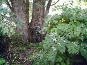
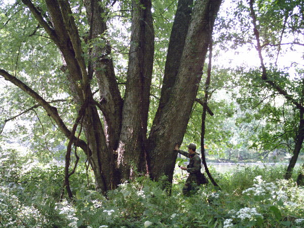
large mulit-trunked sycamore on Courson Island
Of these species several might be expected and are considered
bottom or
wetland species. Sycamore, Silver Maple, and Black Willow are
wet
loving species. In areas like these islands prone to flooding
they are
the dominant species. Often as the trees are battered by
floodwaters
and debris the stems are damaged.
Multiple stem specimens of
these
species are very common or even typical in the case of silver
maple.
One large multi-stem silver maple included at least 7 trunks
fused
together to form a basal mass 24 feet in girth. Slippery elm
(Red elm),
Black locust, and
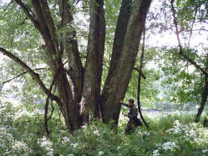
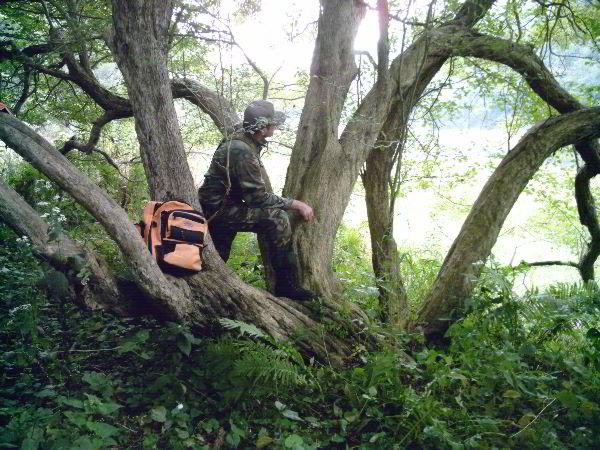
Multi-trunked Silver Maple
Basswood are also not totally unexpected.
Basswood
does form multiple stems on occasion. One example on Baker
island had a
small trunk snaking across the ground before curving upward to
form an
upright trunk.
Basswood with top blown off by tornado - Baker Island
A large 10 foot plus circumference basswood was
found to
be relatively short. When later viewed from the canoe it could
be seen
that the tree was on the edge of the tornado damaged area and
the top
had been blown off at a height of about 70 feet. I had not
expected
that white ash, bitternut hickory, nor hawthorn would be a
typical
species across all of these islands.
Walter and Williams (1999)
had
cited Peachleaf willow as being present
on these islands. It is
difficult to distinguish from black willow. This area
is on the
very
edge of the known range for the species. Normally it is
found
farther
north and west of this area. There were a couple of unusual
looking
willows along the shore of the river noted while canoeing, but
none
were
noted on the islands themselves. Perhaps a more detailed
examination
would show that some of the willows encountered were peachleaf
willow,
but for now the best identification is that of black willow.

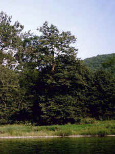
Hawthorne on Baker Island
Dale
Luthringer suggested some potential ages for the trees he first
encountered on Crull Island being in the 100 to 150 year range.
It is
my impression that these trees may be significantly older than
this
first impression. The only way to determine their age for sure
will be
through dendrochronology. I am particularly interested in the
ages of
some of the hawthorn trees on the islands. Some nondescript
species
such as chokecherry and silky dogwood likely have a wider
distribution
but were simply not noted on the other islands in the short
visits.
Other species
Occurred only infrequently or singly on the islands. One in
particular
of interest is the Northern Red Oak. Large specimens were found
on
Crull Island and on Thompson Island, but not on any of the
islands
farther downstream At the same time large examples of the
species could
be seen along the shore of the river. This suggests that perhaps
the
trees were present at one time on the islands but had been
logged at
some time in the past. Similarly only relatively young black
walnut
trees were found on any of the islands.

Butternut on King Island
Butternut was noted in
Walter
and Williams (1999) as a major component
of the flora of King
Island and
one of the other forest service islands they
examined. The
species
however was absent from or not noted from any of
the upper
islands. It
was first noted farthest upstream as a single old tree
on
Courson
Island. Dale Luthinger noted its presence on King Island in
2005,
and
additional examples were found on the Sept 2007 trip. The
largest was a
nearly branchless tree 66 feet high, a small mound of a younger
tree in
a grassland. Much of the southern end of Baker Island had been
hit by
two tornados in 1985. Trees had been blown down. Now this area
is
covered by a similar grassland with patches of trees. In this
grassy
area are mounds of younger butternut trees, very reminiscent in
form to
sumac clumps. I am wondering if these are root sprouts from
larger
trees downed by the tornados? Similarly I am wondering if this
large
grassy area in the central east shore of King Island is a result
of a
wind disturbance from the same time period? The smaller
butternut trees
are similar in size and form to those on Baker Island. Another
point
that seems to support this root resprout idea is that one of the
clumps
of butternut on Baker Island had a broken thick butternut trunk
approximately 7 feet cbh at its base, but otherwise seemed to be
younger
growth.
Other single specimens of note include the Eastern White Pine on
Fuelhart Island. This could be seen from the canoe. The canoe
was held
steady, while I measured the height. Allowing 7 feet for the
height of
the base above the river yielded a height of 115 feet. This tree
could
potentially have been planted, rather than growing naturally on
the
island. The Yellow Birch was found on the far downstream side of
Baker
Island. It was a triple stemmed tree that had been broken off at
a
height of around twenty feet. Each of the three stems were
approximately 1 foot in diameter. It was a legitimate tree
species for
the island. There were several other single specimens – no
additional
comments.
One of the questions that need to be answered is how the
“wilderness” is
fairing with the building of the Kinzua Dam in 1965? With the
normal
flooding cycles removed from the process are the species
composition of
the islands changing? Are those species helped by periodic
flooding-
such as willow, sycamore, silver maple being replaced by those
species
less flood tolerant? Are willows, sycamores, and silver maples
actively
reproducing on the islands?
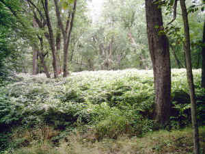
Japanese Knotweed on southern end of Thompson Island
Certainly the ecosystems of the
islands are
drastically compromised by the massive invasions of Japanese
knotweed,
multiflora rose, Japanese barberry, garlic mustard, and Tatarian
honeysuckle. Natural vegetation is not reproducing in areas
dominated
by these species. It is clear that in the channels which are
occasionally flooded these invasives have not managed to
obtained a
strong foothold. In addition they tend to be less dominant at
the upper
ends of the islands which are also more prone to occasional
flooding.
At this point it is politically unlikely that these islands
could be
periodically flooded to remove the exotic species and allow the
native
species to again flourish. Much of the shoreline of the river
has since
the construction of the dam been built up with series of camps
and some
small businesses. Many of these properties would likely be
flooded also
in any attempt to flood the islands. I feel this is what needs
to be
done to restore them and that some accommodation needs to be
reached.
Ed Frank
|